|
Cindy wanted to visit Washington DC and had booked Trafalgar's
Trails of Liberty
Tour for the week of June 18-26th. As I had already visited most
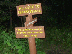
of these sites, I decided it would be a good opportunity for me to continue
my trek down the Appalachian Trail, which I had terminated in Duncannon,
Pennsylvania a few years ago.
We flew to Washington DC, arriving early on the morning of Friday, June
17th. From Dullas we took a Super Shuttle to the Capitol Hilton where
we were able to get into our room immediately. After a shower, we
walked down past the Washington Monument to the Bureau of Engraving and
Printing where we watched greenbacks being printed. After the tour, we
bought tickets to the
Hop-on-hop-off bus tour of Washington and rode the bus past various
monuments listening to the narrated descriptions. The tour included a
boat ride on the Potomac River so we got a chance to see the city from the
water also. After a late lunch at Sequoia in Georgetown, we took a cab
back to the hotel where we stayed for the evening.
Saturday after breakfast at Starbucks, I packed my gear and we headed out.
Cindy has another full day of sightseeing on the bus before the official
start of her tour tonight at 6:00PM. We walked together to The
National Portrait Gallery where we said good-bye and she got on the bus.
I walked over to the intersection of K Street and Capitol Avenue to board
the Megabus to Harrisburg, PA. I had done a lot of research as to how
to get up Harrisburg and at $27 for a 3-hour trip this was the best bet.
However, I had not made a reservation and learned when I got there that
there was no room on the bus and I would not be able to go. So I
continued walking to Union Station where I found a train that would take me
up to Philadelphia and then another train that would take me out to
Harrisburg. The train ticket was five times the cost of the bus and
the trip was supposed to take five hours, getting me into Harrisburg at
4:30PM. This was my only option so I bought a ticket and boarded the
train. The ride was comfortable and when I arrived in Philadelphia, I
was able to transfer immediately to the Harrisburg train so I got there at
2:15PM. I found a taxi whose driver wanted to charge me $50 to take me
15 miles to Duncannon, but he settled for $40 after some negotiation.
 By 2:45PM I was at The Doyle Hotel in Duncannon where I asked them to make
me a sandwich and fill my water bottles for the two-hour hike up Cove
Mountain to the shelter.
By 2:45PM I was at The Doyle Hotel in Duncannon where I asked them to make
me a sandwich and fill my water bottles for the two-hour hike up Cove
Mountain to the shelter.
The Cove Mountain Shelter has an infamous history. It is the location
of a
double murder that took place in 1990. Some people think it is
haunted. I arrived at 5:00PM and was the only person there.
There was a note about porcupines frequenting the shelter so I built a fire
and spent a few hours reading before turning in. As darkness fell,
there were all kinds of noises coming from the woods. I dosed off and
then would wake up upon hearing some strange shriek. About midnight I
was woken by the distinct sound of something gnawing on the bunk a few feet
below me. I got my flashlight to frighten it away, but I only
succeeded in getting it to hide under the bunk. About 30 minutes
passed and it started gnawing again. I turned the light on again but
only heard something, which was probably a porcupine, scurry down the steps.
I did not get much more sleep that night. At 5:30AM I was up and
packing. The Cove Mountain Shelter is 1/2 kilometer down the mountain from
the trail and the intermittent spring is another 1/2 kilometer beyond that.
Knowing this, I filled up my water bottles Saturday night so I only had to
climb the 500 feet up to the trail Sunday morning. I continued over
Blue Mountain hiking a total of 14 miles today to US Route 11 where I left
the trail and walked 1/2 mile west to a Super 8 Motel where I checked in for
the night. After a swim in the pool, I went across the street to the
Middlesex Diner, which was packed with people celebrating Father's Day.
Monday morning I checked out early and walked back up the road to the bridge
where the trail crosses Route 11. The trail is flat for the next ten
miles as it weaves it's way in and around cornfields. In Boiling
Springs, I stopped at Caffe 101 for breakfast and met a group of northbound
hikers. The
Appalachian Trail Conference's Mid-Atlantic Field Office is also in Boiling
Springs, but I only went in for a minute to check it out. I continued
south as I was anxious to reach a place called Whiskey Spring, about four
miles south of Boiling Springs. My 3X great-grandfather, John Good,
operated a distillery in South Middletown, PA almost 200 years ago.
Ancestry research has indicated that Whiskey Spring, which according to the
Appalachian Trail Guide is 'an excellent source of always flowing water’,
could very well be the exact water source for John Good's distillery.
Here is a picture of it today.
Several miles after Whiskey Spring, I arrived at Route 94. I had
arranged for a local innkeeper to pick me up at the trail and take me back
to Mt Holly Springs where I checked into the Holly Inn for Monday night.
The Holly Inn
is a 200-year old tavern with a dozen rooms above a large banquet hall.
It sits in a gap of South Mountain and some 40,000 Confederate and Union
troops passed this way during the Civil War. I ate dinner at the
tavern and met a couple local people who always wanted to hike the AT.
 Tuesday Morning, June 21st, Marie, the innkeeper gave myself and another
hiker a ride back to the trail and we continued our journey, him going north
while I continued south. It rained on and off in the morning but the
forest provided good cover and I did not get too wet. I did encounter
a couple of people hiking naked today, apparently a tradition on the summer
solstice. After Piney Mountain, I reached
Pine Grove State Park where I stopped for lunch. The park is only
a couple miles from the halfway point of the trail and northbound hikers
usually celebrate by purchasing and
eating a half-gallon of ice cream. The park store keeps a log of
the people who accept the challenge and how fast they are able to eat the
full half-gallon. During the hour I was at the store eating my lunch,
eleven hikers took the ice cream challenge. I passed on the ice cream,
but had a sandwich for lunch and then had them make me another for dinner.
I had considered staying at the Ironmasters Mansion Hostel next door, but it
was still early and I continued south. An hour later, I came to the
halfway marker and took my picture. I have come 1090 miles and have a
similar distance to go to reach Springer, Georgia. Tonight I stayed at
Toms Run Shelter after hiking 14 miles today. Tuesday Morning, June 21st, Marie, the innkeeper gave myself and another
hiker a ride back to the trail and we continued our journey, him going north
while I continued south. It rained on and off in the morning but the
forest provided good cover and I did not get too wet. I did encounter
a couple of people hiking naked today, apparently a tradition on the summer
solstice. After Piney Mountain, I reached
Pine Grove State Park where I stopped for lunch. The park is only
a couple miles from the halfway point of the trail and northbound hikers
usually celebrate by purchasing and
eating a half-gallon of ice cream. The park store keeps a log of
the people who accept the challenge and how fast they are able to eat the
full half-gallon. During the hour I was at the store eating my lunch,
eleven hikers took the ice cream challenge. I passed on the ice cream,
but had a sandwich for lunch and then had them make me another for dinner.
I had considered staying at the Ironmasters Mansion Hostel next door, but it
was still early and I continued south. An hour later, I came to the
halfway marker and took my picture. I have come 1090 miles and have a
similar distance to go to reach Springer, Georgia. Tonight I stayed at
Toms Run Shelter after hiking 14 miles today.
Wednesday I awoke to the sound of heavy rain falling on the metal roof of
the shelter. But after an hour, the rain had been reduced to a
sprinkle and I began hiking at 6:30AM. I made good progress and by
10:30AM had reached Milesburn Shelter, the halfway point of today's 16-mile
trip. I continued over Big Pine Flat Ridge and by 2:30PM had reached
Caledonia State Park. I had arranged to stay at the Rite Spot Motel
tonight as they offered a shuttle from the park to their motel, about 4
miles west. The motel was not very good, but it was better than
sleeping in the woods. I did some laundry in my bathtub and then
wandered across the street to the Flamingo Diner, which did offer excellent
home style cooking. Park. I had arranged to stay at the Rite Spot Motel
tonight as they offered a shuttle from the park to their motel, about 4
miles west. The motel was not very good, but it was better than
sleeping in the woods. I did some laundry in my bathtub and then
wandered across the street to the Flamingo Diner, which did offer excellent
home style cooking.
Thursday morning I ate breakfast again at the Flamingo Diner and then got a
ride back to the trail with the motel owner.
He asked for $10, claiming they usually charge $5 each way for their
shuttle service, which would have been reasonable if they told me about it
in advance. I got on the trail
at 7:45AM. There was a light
rain again today, but it cleared up quickly.
The most interesting feature of my hike today was Chimney Rocks,
which is a series of room-size boulders that the trail bores through.
 Some
of the passages are so small that only one person at a time can navigate the
trail. I would have found this
type of thing more fun twenty years ago, but now I think it would be easier
to just go around. I arrived at
Deer Lick Run Shelter in the mid-afternoon after hiking 14 miles today. Some
of the passages are so small that only one person at a time can navigate the
trail. I would have found this
type of thing more fun twenty years ago, but now I think it would be easier
to just go around. I arrived at
Deer Lick Run Shelter in the mid-afternoon after hiking 14 miles today.
On Friday, June 24th, I left the shelter at 6:00AM. Within three hours
I reached the Mason-Dixon Line and the border between Pennsylvania and
Maryland. I stopped for a rest at Pen-Mar State Park where I was able
to buy a drink from a vending machine. Leaving the park, I started the
climb up Quorum Mountain, which at 1880 feet is the highest point on the AT
in Maryland. At the summit, the trail continues along a ridge that
becomes South Mountain. The trail winds its way in and out of large
rock fields that make the going very difficult. South Mountain is the
northern terminus of The Blue Ridge Mountains. This area is rich with
Civil War history with frequent plaques marking the sites of famous
battles and troop movements.
 Gettysburg is only 20 miles east and both Union and Confederate troops
passed this way either in route to or retreating from the battles.
Gettysburg is only 20 miles east and both Union and Confederate troops
passed this way either in route to or retreating from the battles.
At 2:30PM I reached Wolfsville Road and detoured 1/3 mile west to the
Free State Hiker
Hostel where I planned to spend the night. The hostel is owned by
a through hiker who purchased a house and added a large bunkroom for AT
hikers. I did some laundry, ordered a pizza and got a good nights
sleep.
Saturday I had arranged to rent a car from Enterprise in nearby Hagerstown,
MD. They picked me up at 9:30AM and after completing the paperwork at
their office, I drove into Washington DC to meet Cindy who's tour was ending
today. I checked into The Renaissance Hotel and waited for her arrival
in the afternoon. As the hotel is near Chinatown, we ate Chinese
take-out for dinner.
Sunday we went sightseeing in Washington DC. After breakfast at
Starbucks, we walked down to the National Mall and visited the
National Archives where we were able to see the Declaration of
Independence, the Constitution and the Bill of Rights. We went to the
Smithsonian Castle and then walked to the
National Gallery of Art
where we had a great Italian buffet for lunch. Cindy wanted to see
some additional exhibits at the gallery so she stayed while I returned to
the hotel to rest. We ate Chinese take-out again Sunday night.
Monday we had breakfast on the Renaissance Club floor and then checked out.
I drove Cindy to the airport where she was scheduled to take an 11:00AM
flight back to California. I drove back to Hagerstown, turned in my
rental car, and got a lift back to Wolfsville Road. By 11:00AM I was
back hiking south again. I reached Pogo Campsite at 1:30PM where I
took a break before continuing on to the Pine Knob Shelter where I arrived
at 3:30PM and spent the night. I got very little sleep Monday night.
There were several through hikers there who were comparing notes about their
trip through Shenandoah Park where a couple of them had gotten lime disease
from deer-ticks.
 Tuesday,
June 28th, I was first out of the shelter and hiking before
6:00AM. Within three hours I
had reached the original Washington Monument where I climbed to the top.
At 10:30AM, I reached Turner’s Gap and passed the
Old South Mountain Inn. I
would have liked to eat dinner here if I had arrived later in the day, but
it was closed when I passed so I continued my journey.
A few miles later, I noticed smoke coming from the woods about 50
feet off the trail. Someone had
left an illegal campfire burning and it had begun to spread.
I spent about 10 minutes stomping it out with my feet, which resulted
in burning the rubber soles of my hiking boots, but it could easily have
been much worse. Tuesday,
June 28th, I was first out of the shelter and hiking before
6:00AM. Within three hours I
had reached the original Washington Monument where I climbed to the top.
At 10:30AM, I reached Turner’s Gap and passed the
Old South Mountain Inn. I
would have liked to eat dinner here if I had arrived later in the day, but
it was closed when I passed so I continued my journey.
A few miles later, I noticed smoke coming from the woods about 50
feet off the trail. Someone had
left an illegal campfire burning and it had begun to spread.
I spent about 10 minutes stomping it out with my feet, which resulted
in burning the rubber soles of my hiking boots, but it could easily have
been much worse.
I continued through Fox Gap, the scene of heavy fighting during the Civil
War, and on to Ashland State Park and the Civil
War Correspondent’s Memorial, constructed by
George Townsend. After a
half-hour rest and tour of the little museum, I continued on to the Ed
Garvey Shelter where I made my camp after a 17-mile day.
The Ed Garvey shelter is only six miles from Harper’s Ferry and I got up
early Wednesday so I could complete my hike and have a nice breakfast in
town. The trail descends for
two miles, and then follows the old Chesapeake & Ohio Canal towpath for
several miles before crossing the confluence of the Shenandoah and Potomac
rivers on a railroad bridge. In
Washington, the C&O Canal has been preserved and is bordered by beautiful
parkland. Here, however, the
canal is completely filled in with muck and has large trees growing where
barges once plied. As I
approached the town, the valley compresses the old canal and the railroad
tracks that made the canal obsolete, so close that it is a wonder a train
has not derailed into the canal.
During the 75 minutes I spent hiking on the towpath, I counted six
heavily loaded freight trains making their way through the pass.
I crossed the bridge into
Harper’s Ferry,
WV at 9:00AM. Much to my
chagrin, I learned that the town does not start opening until 11:00AM so my
cravings for a good breakfast went unanswered.
Harper’s Ferry is now pretty much a national heritage site, preserved
for tourists. Originally
selected by George Washington to house the nation’s first armory, it was
made infamous when the abolitionist
John Brown attacked the armory to steal the guns and distribute them to
southern slaves. He was
captured and hanged for treason, but many people believe his actions
precipitated the Civil War. The
armory no longer stands, but several other buildings of that era are open to
the public with docent tours available on an hourly basis.
I had completed my hike two days faster than I originally planned due
primarily to the fact that I did not have to take any rain days.
I decided to stay in Harper’s Ferry for two days and used that time
to explore the town and learn about its history.
I stayed at a Comfort Inn about a mile south of the town center, but
it was comfortable.
On Friday, June 1st, I checked out and walked back to town where
I boarded the once-a-day Amtrak train to Washington DC.
After taking the Metro out to Reagan Airport, I flew to Miami where
I’ll stay for the next month while Cindy is in China.
Back
| Map
|
Home
|