 |
Appalachian Trail Harper’s Ferry WV to Rockfish Gap,
VA
April 8-21, 2013
|
|
After crossing the Shenandoah River, the trail ascends 1000 feet and then
generally follows the Virginia-West Virginia border. I hiked at about
2 miles per hour. The weather is spectacular and the forecast is good
all week. I took a rest after the first two hours, and then hourly
after that. By noon I was out of water with several miles to go to my
destination where water would be available. I'll need to be more
cognizant of drinking, especially during the hot afternoons. At 2:15PM
I reached Blackburn Shelter and stopped for the night. There is a
caretaker here and a large screened porch where I spent the afternoon
reading. Several hikers stopped to get water, but continued on.
One man told me he was doing a 60 mile hike, which didn't seem too
impressive, until he added he hoped to finish in 28 hours. One woman
joined me in the shelter that night. I slept very poorly on my thin
air mattress.
I was up early on Tuesday, packed and was hiking
before 7AM. I had hoped to go ten miles today as my legs were not as
sore as they could have been, but I met a man named Scott from the area on
the trail who convinced me that since I was entering the 'Roller Coaster'
(ten 500 foot mountains, one right after the other) I should not be so
ambitious and instead stay at Bears Den, about 8 miles south. He was
right. I soon became exhausted climbing and descending the small
mountains. At noon I reached Route 7 and saw an ad for The Horseshoe
Curve Restaurant about a half mile away and diverted to have some real food.
An hour later I was ascending the last of my 500 foot peaks of the day and
shuffled into Bears Den Hostel around 1:00PM.
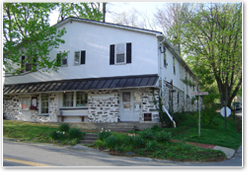
Bears Den
is a stone house purchased by the Appalachian Trail Conservatory many years
ago and is open to the public, but there is a hiker’s hostel around back
that has a combination lock. The combination is the distance in miles
from Front Royal to Bears Den, so if you are a hiker, you can figure it out.
I am the first hiker here this day and quickly made myself at home, checking
the Internet, showering and relaxing in a bed with a real mattress.
Today I will hike to Rod Hollow Shelter, a distance of only about 8 miles.
It has been unseasonable hot and the forecast is for the upper 80's for the
next couple days. A half hour after leaving Bear's Den Hostel, I saw
the first bear I have ever seen on the AT. Fortunately the bear saw me
first, so I was only able to see it darting up the hill away from me, but it
was probably only 30 yards away when it ran. I also saw several groups
of white tailed deer which would scatter whenever they saw me.
When I planned this trip, I had neglected to bring sunscreen as I would be
hiking in the woods and did not think there would be too much sun.
However, I failed to realize that there are no leaves on the trees yet, and
I might as will be hiking on a beach. There are beautiful wildflowers
including irises and some type of wild daisy which are growing in the woods
which stand in contrast to the drab grey of tree trunks and leaves.
Around 1:30PM I completed the last of the 'Roller Coaster' hills and started
looking for Rod Hollow Shelter. In the distance I could hear someone
playing a flute, which is not an everyday occurrence deep in the woods.
As I approached Rod Hollow, I came across a young girl playing the flute by
a stream. She was a member of a Montessori High School Group from
Cincinnati that was on a one-week hike on the Appalachian Trail, headed
north. Tonight I would share the campsite with about 30 people.
Travis had also stopped briefly at Rod Hollow for lunch, but was continuing
on to another shelter in the afternoon.
I inflated my air mattress and sleeping bag in the shelter and lay down.
Large groups are not supposed to use the cabins and this group had tents
that they would be sleeping in. The group had hiked eight miles today
and got into camp only a half hour before me. They had one student who
was not used to hiking, had been sick a half dozen times, and with a high
temperature and blisters, they needed to send him home. I helped them
coordinate his evacuation as I had the only cell phone which worked, and
suggested that they just hike to the nearest road and arrange to have Justin
from Bear's Den pick them up, rather than hike the eight miles over the
'Roller Coaster' to get to Bear's Den. The group had some good
activities including a sharing session, journaling, and threats to reduce
the grade for the trip by the headmaster when talking in the tents continued
past 9PM bedtime.
I left Rod Hollow before 6AM Thursday. This day is forecast to be even
hotter than yesterday's 86 degrees and I wanted to get as much trail in as
possible before it got too hot. My legs are not as sore today as they were
yesterday morning so perhaps I am getting my trail legs back. The
topography is somewhat easier today as the constant ups and downs of the
'Roller Coaster' are behind me. I met Travis again as he had slept in
today and I got a three hour jump on him. We hiked together for a
while, but he is faster than I and I didn't want to hold him up so I took a
break and he kept going. I had originally planned to stay at the Manassas
Gap Shelter, a hike of about 13 miles, but the forecast is for rain Friday
morning and I decided to go on to Route 55 where I hitchhiked into Front
Royal and took a room at The Quality Inn.
I showered, and went for dinner. I looked for a place I could buy more
iodine tablets, but could not find any. I slept until about 4AM, and
then woke. At 6AM the downpour came and I was very glad I was not
caught out on the trail. The forecast is for the rain to stop around
noon, so I will probably keep my room for another night, but slack-pack an
8-mile section this afternoon, and then return to the motel for another
night.
I called a taxi to take me back out to the place where I stopped hiking
yesterday. With a light pack, I quickly hiked the eight miles from
Route 55 over to Route 522. As I approached the end of today's hike I
saw a large 8-foot fence with barbed wire running up the mountain in the
woods. Curious as to what needed to be protected, I inquired and
learned that this area houses part of the National Zoo and many animals that
are not currently in the zoo are kept here. I also found out that the
ATF dog-training facility is here in Front Royal and border patrol personnel
from all over the world come here to work with the dogs. I hitchhiked
back to Front Royal, showered and had dinner before returning to sleep
early.
The next morning I checked out of The Quality Inn and again took a taxi back
to the trail. The cab driver told me to be on the lookout for Morrell
mushrooms which seem to sprout in this area after heavy rains.
I soon discovered, however, that the heavy matting of dead leaves
covered any evidence of sprouting mushrooms.
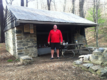
I hiked 13 miles up over North and South Marshall Mountains and then
descended to Gravel Spring Hut for the night.
There was a local camper at Gravel Spring who had recently lost his
job as a firefighter for the federal government.
Significantly bigger than me, I became somewhat concerned as he
consumed two quarts of liquor over a two hour period, but he eventually left
and I was able to relax.
On April 14th, I hiked another 13 miles up and over Hogback
Mountain and Pass Mountain to Pass Mountain Shelter.
After settling in, I heard more hikers approaching and it turned out
to be Scott whom I had met a few days ago, and his family.
They stayed for an hour and then left, so I spent the rest of the
afternoon reading. I did not
sleep well this night as there were mice in the shelter and their scurrying
around kept me awake. To make
matters worse, it started to rain about 5:00AM.
I was anxious to get to
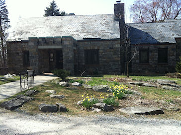
Skyland Resort
in Shenandoah National Park so I hiked 10 miles Monday in the rain and wind.
Hiking was miserable, but I arrived at the lodge around noon and
checked into my room. After a
shower and lunch in the restaurant, I turned on the TV and within two
minutes CNN interrupted their regular broadcasting with the first reports of
the Boston Marathon bombings. I
spent the rest of the day glued to the TV.
At dinnertime, I made the ¼ mile hike back up to the restaurant for
dinner.
Tuesday, after breakfast, I checked out of Skyland and continued south.
I stopped at Big Meadows Wayside for lunch and then continued on to
Bearfence Hut for the night, a total of 16 miles.
It rained again during the night, but was clear in the morning when I
left and hiked 9 miles to Swift Run Gap where I hitchhiked down towards
Elkton where I found the Country View Motel and checked in for the night.
The motel’s owner, Bob, was very nice offering to drive me to town or
wherever else I may need to go.
The room itself was poor, but considerable better than sleeping in a
shelter. I walked a half mile
to a country store where I had some chicken and purchased food for the next
few days. I was also able to
finally find iodine tablets to treat spring water.
Dave left Pinefield before 6AM the next day and I followed him about 15
minutes later. There is a front
moving in and thunderstorms are predicted for early afternoon.
It is cold and windy with occasional light rain today.
I stopped at Loft Mountain Campground but it was closed and no one
was around. I was able to take
shelter in the breezeway of the closed laundry building and took the
opportunity to charge my cellphone at an outlet used for the vending
machine. Knowing that the storm
was coming, I pushed on in the rain reaching the summit of Blackrock
Mountain around noon. I
continued to descend the mountain to Blackrock Shelter where I unpacked and
crawled into my sleeping bag to await the storm.
During the afternoon, several other people arrived at the shelter.
At 4PM, the thunder and lightning started and a downpour ensued.
Even though we were dry in the shelter, the storm was violent, but
short.
Saturday morning I packed early and was the first to leave the shelter.
Although I had planned to hike 21 miles today to Rockfish Gap, my
knee started bothering me and after only 8 miles, I stopped at Turk Gap and
hitchhiked down to Waynesboro where I checked into a Quality Inn.
I did some laundry, had dinner and made contact with Bill Gallagher,
a local Trail Angel, who offered to provide me with transportation in the
Waynesboro area.
Sunday morning, my knee was still bothering me.
I was determined to go back to Turk Gap and complete the 13 miles I
had not hiked yesterday, but I did not think I would be able to continue on
to Roanoke as originally planned.
Bill picked me up at 8:30AM and took me back up the mountain.
The weather was excellent and it took me about six hours to complete
the final 13 miles from Turk Gap to Rockfish Gap.
My knee held up, but I could feel pain with each step.
As I was approaching the final set of switchbacks, I called Bill who
came out and drove me back to The Quality Inn in Waynesboro.
I decided to stop here at Rockfish Gap rather than try to continue to
Roanoke, which turns out to be 50 miles further than I originally thought.
I have hiked 163 miles in two weeks and will return to continue my
trek at some point in the future.
Bill picked me up Monday morning and drove me to Charlottesville
Regional Airport where I boarded a US Airways flight back to San Francisco. |
|
 Bob
gave me a lift up the hill the next morning at 7AM.
Bob
gave me a lift up the hill the next morning at 7AM.