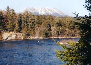
Thursday, July 3, 2003 – Millinocket, Maine After taking a couple months off from traveling to attend to some personal business, I’ve decided to start hiking the Appalachian Trail – the 2100-mile ‘Walk in the Woods’ from Georgia to Maine. It seemed appropriate to start at the beginning (or at least one end) of the trail, so I spent yesterday traveling by train, bus and taxi from Stamford, CT to Millinocket, ME, the closest town to the northern terminus of the trail on Baxter Peak at Katahdin. I arrived at 8:30 PM last night and checked into a local motel for two nights. This morning I took a taxi 25 miles out to Baxter State Park where I began the 2-¾ mile climb up Abol Trail to Baxter Peak. Although I only had a small daypack, it took three hours to climb the difficult terrain to the summit, which is the highest point in the state at 5,271 feet. Last weekend, a young person from the local community had suffered heat exhaustion and died on this mountain, but today it was drizzling so the weather was much cooler. At 10:00 AM, I reached the summit and the beginning of the Appalachian Trail southbound to Georgia. The descent seemed more difficult than the ascent and I did not reach Katahdin Stream Campground until 2:00 PM. From here, I continued another nine miles to Abol Bridge Campground where I arrived at 6:30 PM. Along the way, I crossed a beaver dam and saw two beavers chewing down trees about 50 years away. Today I hiked for 12 hours covering 18 miles and was very tired. I hitchhiked the 25 miles back to my motel in Millinocket where I had dinner in the restaurant and spent my final night before embarking into the ‘100 Mile Wilderness’ tomorrow. Friday, July 4, 2003 – Rainbow Springs Campsite, AT, ME I packed, checked-out and took a taxi to the Abol Bridge Campground where I had left off last night. After buying a soda and some fishing gear, I started hiking the ‘100 Mile Wilderness’ at 8:50 AM. There are no services, roads, towns, houses, food or civilization until I reach Munson – over 100 miles south. I hope to get there in a week. I shortly realized that my pack, at 75 lbs, was enormously heavy. I had only taken a small daypack yesterday so today is my first day carrying all my gear. My progress is slow and the humidity is high with occasional showers. During the day, I met six people hiking from the opposite direction – all with packs half the size of the one I have. I had hoped to hike 15 miles today, but I am only able to cover 11 miles. The mosquitoes are horrible and I pass the time making a game of trying to drown them in the rivers of sweat that flow down my arms and legs. At 5:30 PM, I arrive at the Rainbow Springs Campsite where I set up my tent for the first time. My feet are covered with blisters, which I’ll have to deal with before setting off tomorrow. I swam in the lake for a few minutes to cool off and when I got back to the campsite, I had been joined by a northbound hiker who lectured me on the amount of stuff I was carrying. I ate a bagel for dinner and went to sleep early. There were thunderstorms and lightening which lit up the forest during the night. Saturday, July 5, 2003 – Pollywog Gorge, AT, ME My legs and feet are so sore that I considered staying here another day. The storm has passed, however, and I am sure I can make at least another five miles, although I’d like to go 12 to a further campsite. I left Rainbow Springs Campsite at 9:45 AM and arrived at Rainbow Stream Lean-to at 12:30 PM – a distance of only 3.8 miles. The hiking is much more difficult than I thought as the trail is covered with roots, rocks, mud and slippery bogs which must be negotiated. I took an hour break at the lean-to & had a swim while my boots and socks dried in the sun. I still had a little energy so I packed up and continued on reaching Pollywog Gorge at 3:00 PM. At this point, I started looking for a place to pitch my tent because I knew I wouldn’t make it to Wadleigh Stream Lean-to as I still had Nesuntabunt Mountain to get over. I found a great place near the trail at the foot of the gorge and set up my tent. I swam in the river, and then ate a power bar for dinner because I did not have the energy to cook. I went to sleep at 5:00 PM with the intention of getting an early start tomorrow. Today I only hiked 7 miles. Sunday, July 6, 2003 – Nahmakawta Stream Campsite, AT, ME I got an early start today and was packed and hiking by 7:30 AM. My legs are still sore and my feet are covered with blisters. I also have developed blisters on my shoulders and sides where the pack straps chafe against my body. One of the people I met along the trail told me of a place a day from here where you can hike off the trail to a place called White House Landing where you can mail extra stuff home. I need to lighten my pack by about 20 lbs. I hiked over Nesuntabunt Mountain, only 1560 feet but exhausting nevertheless, and continued down the other side. I stopped at a sandy beach on Lake Nahmakanta for an hour where I swam, dried my wet clothing and found some wild strawberries. At 2:00 PM, I continued on, reaching the end of the lake at 4:00 PM and Woodsrat Spring at 4:30 PM. I had planned to stay near the spring, but there was no place to pitch a tent so I plodded on until 6:15 PM when I saw a great campsite next to the river. I believe I am only ¼ mile north of Nahmakanta Stream Campsite, but I cannot go on any further. I had planned to cook my first meal tonight, but after cooling off in the stream, I am too tired to cook so I ate half of an energy bar, drank some water and went to sleep. Today’s hike was 11 miles. Monday, July 7, 2003 – White House Landing, Pemadumcook Lake, ME Last night was the first night it did not rain. Although I was exhausted, I got very little sleep. I got an early start and plan to take the detour to the place where I can lighten my load – which I think is about three miles from here. I understand you can also buy food there so I’ll be able to get something to eat. By 8:15 AM, I had walked the three miles and stood on the western shore of Pemadumcook Lake. Here, attached to a tree, was an air horn with instructions to blow the horn and the owner of White House Landing would come in his boat to take you to the other side of the lake where the lodge was located. I only had to wait about 10 minutes and got a ride back to the lodge. White House Landing turned out to be a wonderful collection of a half dozen buildings with a restaurant, bunkhouse, showers, laundry…just about everything a hiker needs. It turns out they are famous for their ¾ pound hamburgers and pizzas. I ate a huge breakfast and decided to spend the day and one night here recovering. I did some laundry, packed up about 15 pounds of gear I thought I could do without (including my camera), and mailed it home. Several other hikers blasted the air horn during the day and Bill, the owner, was kept busy ferrying hikers across the lake. At dinner, I ordered a pizza, and some of the other guests ordered the famous hamburger, which was huge. Today I only hiked 3 miles. Tuesday, July 8, 2003 – Cooper Brook Falls Lean-To, AT, ME I slept well but was woken at 4:45 AM by the sound of rain on the bunkhouse roof. It gets light pretty early here so I got up to see if the rain might be an excuse to spend another day here in the lap of luxury. The rain had slackened by 7:00 AM and one of the other hikers had heard a weather forecast calling for somewhat sunny skies until later in the afternoon, when there was a thundershower predicted. I decided to pack and leave – but not before another all-you-can-eat hiker breakfast. During breakfast, I discovered that Bill and his wife had bought the camp nine years ago from Irwin & Muriel Bacon, schoolteachers from Connecticut. At 9:00 AM Bill took myself and a northbound hiker named Fixey back across the lake where we resumed hiking in opposite directions. I am 30 lbs lighter now than when I started (half equipment I mailed back to CT and the other half weight I’ve lost so far), and I now have a walking stick that I acquired at the camp so I am able to make good progress. By noon I had reached Antlers Camp, the first of my possible stopping points, but continued on past Jo-Mary Road to Cooper Brook Falls Lean-To, a total of 14 miles. Here I met Cyrus and his sisters, Julian and Mary, whom I had run into before and had originally suggested I stop at White House Landing. The falls are beautiful, but since I mailed my camera home to reduce the weight in my pack, I cannot take pictures. I went for a swim, set up my tent and was in bed by 7:00 PM. Wednesday, July 9, 2003 – Logan Brook Lean-To, AT, ME I packed early and was hiking by 6:30 AM. Although I didn’t eat anything yesterday after breakfast, I don’t feel famished. I’m drinking about 8 liters of water each day so I guess that is keeping me full. I plan to cook dinner for the first time tonight. By 9:00 AM I was atop Little Boardman Mountain and had reached East Branch Lean-To by noon. I rested at East Branch for an hour, and then continued on to my destination - Logan Brook Lean-To. Today’s hike was 11 miles and included getting me halfway up the slopes of White Cap Mountain. I’ll finish 3700’ White Cap tomorrow morning. Cyrus, Julian & Mary are here tonight also. I cooked two pasta dinners tonight, but could not finish it all. Thursday, July 10, 2003 – West Branch Pleasant River, AT, ME Today I was up, packed and hiking by 6:20 AM. I had the final 1200’ of White Cap Mountain to climb, and then continued over three lesser mountaintops reaching Carl Newhall Lean-To by noontime. After resting for a while, I continued 3 ½ miles to the Gulf Hagas Cut-off, where I left the AT for a 5-½ mile detour to see this large natural slate canyon. The canyon has numerous waterfalls and the side trail follows the canyon down the mountain. By 6:00 PM I had regained the AT and forded the West Branch of the Pleasant River at 6:30 PM. I found a small campsite just off the trail and set-up my tent for the night. Today I covered 18 miles, 5 ½ of which was the Gulf Hagas sidetrack. Friday, July 11, 2003 – Chairback Gap Lean-To, AT, ME I packed up and left at 6:30 AM for what I planned to be a 10-15 mile day. The hike up Chairback Mountain was difficult – and then it started to rain. The closest shelter was a lean-to 4-½ miles up the mountain and I pushed on in the rain until I finally reached it. There was no one at the lean-to when I first arrived and I spread out my sleeping bag inside and tried to warm up. Over the next six hours, more people arrived at the lean-to than I had seen in the entire last week combined. Two groups of ten persons each (groups are not suppose to use the lean-tos and they camped nearby), as well as numerous threesomes, couples and individuals. Cyrus and his sisters arrived at 11:00 AM and as it continued to rain all day, we hung out and eventually decided to spend the night there. Today’s hike was only 4 ½ miles. Saturday, July 12, 2003 – Wilson Valley Len-To, AT, ME I hit the trail at 5:20 AM before anyone else was awake. The rain had stopped but it was still overcast and the trail was very wet and slippery. I hoped to get 17 miles today to Wilson Valley, but could also stop at 12 if I was tired. I felt pretty good and although the going was slow, the weather held and I was able to get to Wilson Valley by 5:20 PM – exactly 12 hours after I started. I stopped along the way for a swim, which was very refreshing. The Wilson Lean-To has six other people – three of whom I have camped with before. Tomorrow’s forecast is for scattered showers in the afternoon, so hopefully I can cover the last ten miles of the 100 Mile Wilderness by early afternoon. Sunday, July 13, 2003 – Shaw’s Guesthouse, Monson, ME Of the seven people who stayed at the Wilson Valley Lean-To last night, I was the first to leave at 6:45 AM. I headed down over the Canadian Pacific Railroad tracks, and then removed my hiking boots to ford the Big Wilson Stream. On the opposite side, I took a wrong turn, but corrected my mistake after only five minutes. Today’s 11-mile hike did not include any big mountains, but was difficult anyway because the ground was slippery. Twice, I slipped falling flat on my back, which would have been incapacitating, had I not been wearing a large pack. By 1:00 PM, I had reached the Leeman Brook Lean-To, but did not stop as I only had three miles to go at this point. I reached Maine State Highway 15 at 2:15 PM. Here I hitchhiked four miles into Monson where I checked into Shaw’s Guesthouse. Shaw’s is a legendary stop for many AT hikers as it is the last supply point for northbound hikers before the 100 Mile Wilderness, and the first supply point for southbound hikers after the wilderness. There are about 20 people staying here. Dinner was steak (Shaw raises and slaughters his own cattle) and lots of potatoes and vegetables. The food was great, even though I skipped the meat. My room has a TV with CNN so I am able to catch up on the news. Monday, July 14, 2003 – Shaw’s Guesthouse, Monson, ME Today I took a ‘zero day’ – AT lingo for a day off with no hiking. I explored the town of Monson, finding an Internet point at the library, a post office and a general store. I mailed an additional 5 lbs of unnecessary gear back to myself, lightening my load to about 55 lbs. I learned that Monson was the slate capital of the northeast in the early 1900’s and I visited an old slate quarry just up the street from where I’m staying. After checking my email and learning there was no compelling reason to return to Connecticut, I decided to keep hiking south at least as far as Caratunk at the Kennebec River. I skipped dinner tonight and went to bed early so that I could leave at 5:00 AM. Tuesday, July 15, 2003 – Bald Mountain Brook Lean-To, AT, ME Keith Shaw gave me a ride out to the trailhead at 5:00 AM and I continued south. Within 15 minutes, I heard a loud crashing sound through the woods about 75 yards away and just caught a glimpse of my first moose as it huffed and snorted to indicate it’s displeasure at being disturbed. An hour later, as I was getting ready to ford the Piscatagins River, I heard a second moose running through the shallow water. By 8:00 AM I had reached the Horseshoe Canyon Lean-To and continued on making excellent progress. I had originally planned to stop for the night at Moxie Bald Lean-To, but after having a short swim there in the lake, I decided to continue up and over the mountain, enabling me to complete map 4 in two long days instead of three regular days. I met up with Don & Murph, who I had run into on several occasions before and hiked with them for awhile, but when we reached Bald Mountain Brook Lean-To, I unpacked for the night and they continued on for another few miles to find a different campsite. A local resident stopped by the lean-to with his sons and told us we could find blueberries, which were ripe under the power lines ahead. Today I hiked 20 miles, my longest day so far. Wednesday, July 16, 2003 – Caratunk House, Caratunk, ME The bugs were so nasty last night; I pulled out my tent and set it up inside the lean-to in the middle of the night to keep from being eaten alive. I left at 5:30 AM with the intention of hiking 15 miles to Caratunk. The weather was supposed to be good in the morning with possible showers in the afternoon. After a few miles, I passed under the power lines and found blueberries, which had ripened in the sun. Continuing on, I summated 2500’ Pleasant Pond Mountain by 10:00 AM and could see the clouds closing in. I had planned to stop for lunch at Pleasant Pond but decided to keep going to try and make it to Caratunk before it started to rain. I arrived at 1:00 PM, just as it started to drizzle. The local B&B here is Caratunk House where I checked in and discovered there was a massage therapist, who I scheduled for 4:00 PM. I took a second shower after my massage and went back to my room to read. At 6:00 PM, Don & Murph, who were staying at a different house owned by a friend of Don’s, came by and we all went to dinner at a place called ‘Northern Outdoors’ which caters to river rafting clientele. We ate a huge meal and then returned to Caratunk House at 8:30 PM where I spent the rest of the evening reading. Thursday, July 17, 2003 – Long Falls Dam Road, AT, ME I awoke early and read until breakfast was served at 8:00 AM. There were four of us at Caratunk House last night…Rocky, myself and a couple from Connecticut who were retired from Xerox. Breakfast was the usual all-you-can-eat waffles, blueberry muffins, eggs, potatoes, fruit etc. At 8:45 AM I paid my bill and headed out. The first thing on the agenda today was to take the ferry across the Kennebec River. Too dangerous to ford because of frequent releases of water from the upriver dam that can raise the level of the river several feet in a few minutes, the Appalachian Trail Club provides a free ferry service, which keeps most hikers from swimming across the 50-yard river. The ‘ferry’ consists of a canoe and a person to paddle it. After the crossing, I started on a relatively easy hike, as there were no mountains today. I stopped at East Carry Pond at 2:00 PM to go swimming. I passed West Carry Pond Lean-To and continued over Roundtop Mountain until I found a tent site near a stream where I set up camp for the night. I could hear the traffic on Long Falls Dam Road so I think I hiked about 18 miles today. The next two days will be short but steep. Friday, July 18, 2003 – The Col at Avery Peak, AT, ME I was packed and hiking by 6:30 AM. Today, I’ll hike up Bigelow Mountain, at 4100’ the highest peak since Baxter. By noon I had summited Little Bigelow and had planned to set up camp in the site between Little Bigelow and Big Bigelow, but the site was ¼ mile off the trail and I didn’t feel like doing the extra mileage. I continued up Avery Peak on Bigelow Mountain resting often due to the steepness of the climb. I reached the open summit at 2:00 PM and had clear views in every direction. I decided to stay in the Col between Avery Peak and West Peak. Although there is suppose to be a lean-to here, it seems to be missing, so I erect my tent on one of the wooden platforms provided by the Park Service. Immediately after I got into my tent, it started raining. After a 2-hour rest, I prepared dinner of noodles and enjoyed it outside as the rain had stopped. Today I hiked 11 miles. Saturday, July 19, 2003 – White Wolf Inn – Stratton, ME Although today was to be a shot day, I packed up and left early. It took fifteen minutes to summit West Peak, and then another hour to go over South Horn. At Horn’s Pond Lean-To, I met three women with whom I hiked down Bigelow Mountain. We arrived at the bottom at 11:30 AM and they gave me a ride to Stratton in the car they had parked there a week ago. We ate lunch at the Stratton Diner and then I checked into the White Wolf Inn. I had offered them the opportunity to shower in my room, but the room was not ready yet so they left without waiting. I decided to continue hiking tomorrow even though the next section looks particularly difficult. I went to a couple stores to resupply with food, fuel and iodine tablets. Back in my room I did some laundry, watched ‘The Tour du France’ on TV and ate dinner. Today I hiked 8 miles. Sunday, July 20, 2003 – Sandy River & Rangeley Lakes RR Bed above Oberton Stream The forecast is for heavy rains on Tuesday and Wednesday so I’m going to try to get to Rangeley by tomorrow night and wait out the storm at The Rangeley Inn. This means I’ll have to hike 32 miles over two mountain ranges with several 4000’ peaks in two days. I packed up and went to breakfast at the diner at 7:00 AM. Mark, AKA Clearwater, another southbound hiker whom I had originally met on the bus from Bangor and had seen several times since, joined me in the booth. He’s taking today off to go 40 miles to the Wal-mart store to get a prescription filled. At 7:30 I picked-up my pack and started hitchhiking the six miles from Stratton to the AT trailhead. I got a ride right away and was hiking before 8:00 AM. I felt real good today and the hours passed quickly. I summited the north and south peaks of Crocker Mountain before noon and was on to Spaulding Mountain in the afternoon. I passed the cut-off trail that leads to the popular ski resort Sugarloaf, whose slopes I had been viewing for the last several days from afar. The weather was great and in an attempt to cover as much ground as possible, I hiked on until 7:30 PM. When I reached the old narrow gauge railroad bed above Oberton Stream, I decided it was time to pitch my tent. There is a group of Boy Scouts from PA camped here also. I made dinner and turned in by 8:30 PM. Today I hiked 19 miles, leaving only 14 until I reach Route 4 to Rangeley tomorrow. Monday, July 21, 2003 – The Rangeley Inn, Rangeley, ME Last night was awful. I had a terrible pain in my back, which kept me up most of the night. I was also sick to my stomach several times and couldn’t even hold down water. By 6:00 AM, the back pain had subsided, but I still felt awful. Unfortunately, there is no other option other than pack up and start hiking. With the storm coming, I didn’t want to stay where I was because I thought I might get caught there for several days, so I needed to get over Saddleback Mountain to Rangeley. The hiking in the morning was extremely slow, averaging only one mile per hour. By late morning I was beginning to feel better and by noon I had completed the third and final peak of The Saddlebacks. It was very windy on top and fog was blowing over the mountain. When it started raining, I still had six miles of descending over slippery rock. I made good time, however, and by 4:00 PM had reached Maine State Route 4 where I was able to hitch a ride with a state trooper nine miles into Rangeley. I checked into The Rangeley Inn and immediately got into the bathtub to soak. The tub in my room was either enormous or I’ve lost so much weight I can now fit in a regular size bathtub. I’ll have dinner tonight in the Inn’s restaurant, and then relax here for a couple days while the storm passes. Today I hiked 14 miles. Tuesday, July 22, 2003 – The Rangeley Inn, Rangeley, ME Today was my second ‘zero day’. I was actually disappointed it didn’t rain harder because I felt I could have hiked today. I wandered around Rangeley, spending some time on-line at the library, buying supplies and doing laundry. I walked down to ‘The Red Onion’ for dinner. Both of the last two nights I’ve eaten dinner early and found both restaurants packed at 5:30 PM. Tomorrow I plan to take another ‘zero day’ and hopefully find a massage therapist. Wednesday, July 23, 2003 – Rangeley Inn, Rangeley, ME Today it rained on and off all day. I was able to find a massage therapist who came to the Inn at 2:00 PM for a 90-minute session. In the afternoon, I went to the library and spent some time on-line. Since I had had no exercise today, I decided to skip dinner. Thursday, July 24, 2003 – Bemis Mountain Lean-To, AT, ME I ate blueberry pancakes for breakfast and checked-out of The Rangeley Inn at 8:00 AM. I got a ride with the first car that passed me which took me the nine miles up to the trailhead. By 8:20 AM I was hiking and by 8:30 AM it had started to rain. Having spent the last three days in a hotel to avoid the rain, I was disappointed, but kept going. I had originally planned to go only to Route 17 and then hitchhike to town, but decided when I got there that I would keep going and hike up the Bemis Mountain Range four miles to the lean-to and stay in town tomorrow night. I’d like to be at the New Hampshire border by the 29th, so I can’t take any more ‘zero days’. The lean-to was crowded with north bounders and south bounders, some of whom I had met before. Today I hiked 17 miles. Friday, July 25, 2003 – Andover Guest House, Andover, ME My boots were still soaking wet when I put them on this morning. I packed up and left at 6:50 AM to finish my ascent of The Bemis Range. The trail is very wet from yesterday’s rain and the descent of Old Blue Mountain was particularly difficult. I got to South Arm Road at 12:30 PM where I waited 45 minutes for a shuttle into Andover. I checked into the Andover Guest House and did some laundry. The Andover Guest House was run by a guy named Pegleg, who just passed away a few weeks ago. His wife who seems to be overwhelmed is now running it. Rather than shuttle hikers around (a common service provided by innkeepers on the trail), she just gives you the keys to her van and tells you to drive yourself. I located a massage therapist who picked me up and took me to her home for a 90-minute session. I got back at 8:30 PM, bought a pizza for dinner and watched TV for a while before going to bed. Today I hiked 8 miles. Saturday, July 26, 2003 – Andover Guest House, Andover, ME Today I slack-packed for the first time. Slack packing is leaving your heavy pack at the Guest House, hiking with just a small pack containing water and other essential items, and then returning to the same Guest House in the evening. What a huge difference it made not having the heavy pack! I felt I was floating up over the mountains. I woke early and went for breakfast at the restaurant next door. I ordered the ‘Challenge’ breakfast…3 pancakes which are free if you can eat them. The pancakes are 15” across and served on a pizza platter. Although I was hungry, I ate only about one-third of my stack. I returned to the Guest House and Sandra, the Innkeeper, gave me a ride out to the trailhead. I started hiking at 8:20 AM and although the terrain for today looked difficult, it was dry and I was able to cover ground quickly. I was up and over Moody Mountain in two hours, and then went on to Wyman Mountain. During the day, I met several hikers including the ‘caretaker’ for this portion of the AT. Apparently, every section of the AT has someone who looks after it and reports on what needs to be done to keep the trail in good shape. I had asked Sandra to pick me up at East B Hill Road at 3:30 PM, but I was able to get there by 2:00 PM and hitchhiked back into town. In the afternoon, I played ping-pong with Clearwater and Zigzag and then we all went to dinner next door at 7:00 PM. Cyrus, Mary & Julian showed up later that evening and stayed at the same Guest House. Sunday, July 27, 2003 – Bethel Inn & Country Club, Bethel, ME I got up at 5:30 AM this morning and packed to ‘slack-pack’ again to Grafton Notch. Clearwater, Zigzag and I had breakfast at the general store, and then Sandra gave us a ride out to the trailhead on East B Hill Road where five of us (including a couple from Ohio) set off on the 10-mile hike to Grafton State Park. We hiked fast as the weather was threatening, but we were lucky and it did not rain. We got to the park at 1:15 PM and had to wait an hour for Sandra to show up with our packs. From Grafton Notch, the others continued on to the next shelter with plans to hike Mahoosuc Notch tomorrow. I hitchhiked 18 miles into Bethel where I checked into the Bethel Inn & Country Club where I planned to get together with Al & Linda, friends from New Hampshire whom I had met in Africa last year. After showering, I had an excellent dinner in the Inn’s restaurant and then went back to my room for the evening. Monday, July 28, 2003 – Bethel Inn & Country Club, Bethel, ME I took another ‘zero day’ today and met Al & Linda who came over for the day. We ate lunch at the Inn and then spent the afternoon at the pool. They brought pictures of their recent trip to Europe and their ‘Tour du Mont Blanc’, and subsequent attempts to summit Mont Blanc. They left in the late afternoon and we planned to get together again when I got to New Hampshire. I ate dinner in the restaurant again and returned to my room for the evening. Tuesday, July 29, 2003 – Full Goose Lean-To, AT, ME I checked out of The Bethel Inn and had my final breakfast in the restaurant. The Rotary Club was meeting in the next room and they started their meeting by singing ‘America the Beautiful’ before they ate. I had tried to get a taxi to take me out to the trailhead, but none were available so I hitchhiked. After walking through town, I got a ride in less than 10 minutes, which took me the full 18 miles and dropped me off at Grafton State Park where I had stopped the other day. My first objective was the 2500’ ascent of Old Speck Mountain – Maine’s third highest. It took just over two hours and I took a break at the Speck Pond Shelter. By noon I was descending the Mahoosuc Arm en route to Mahoosuc Notch. Mahoosuc Notch is known as the ‘Miracle Mile’ and is reported to be the most difficult mile on the Appalachian Trail. House size boulders have accumulated in the notch and the trail winds over, under and around the huge rocks. It took me 80 minutes to navigate my way through the notch, twice having to remove my pack to squeeze through small openings. After the notch, there was a steep ascent of Falling Mill Mountain, and then another mile to Full Goose shelter where I spent the night. The site was crowded, but most people had tents, so the lean-to was not full. I cooked dinner and read for a while before going to sleep. Today I hiked 10 miles and this is my last night in Maine. Wednesday, July 30, 2003 – Gelatine Pond Lean-To, AT, New Hampshire Cyrus and his sisters came into camp at 11:00 PM last night, after hiking in the dark for two hours. I was up and packed by 6:50 AM so we didn’t visit much, but they plan to stay at the same place as I tonight so I’ll see them there. Today’s hike was only 10 miles but it was difficult from the start. In addition to the hills, there were a couple places where rock-climbing ability was necessary to climb up out of the gorges. The weather was good and at 11:00 AM, I reached the New Hampshire border where I rested and spoke to a north bounder named Claire. When I asked her what her motivation was to hike the entire AT, she responded ‘I forgot’. I continued on over Success Mountain and descended to the Gelatine Pond Lean-To. I went for a swim to wash the sweat off my body, and then settled down to read for a while. The shelter became crowded as the afternoon wore on and we had eight people in the shelter by nightfall. Thursday, July 31, 2003 – Colonial Comfort Inn, Gorham, NH I was hiking by 6:00 AM this morning, anxious to get to Gorham on this, the last day of my hike for the time being. There are only three 500’ mountains to ascend on today’s 11-mile hike. When I got to Mt. Hayes, I took the more direct blue-blazed trail down into Gorham where I found and checked into the Colonial Comfort Motel at 12:30 PM. After showering and doing my laundry, I took a bicycle to the library where I checked my email. Cyrus, Mary & Julian showed up later that day and this is the end of their hike also. In the evening, I took the bicycle again down to a Chinese restaurant where I had dinner. Tomorrow, I’ll take the bus to Boston, and then return to Connecticut by train. I plan to return to The Appalachian Trail in late September to hike the 162-mile section in New Hampshire. | Back | Map | Home | |