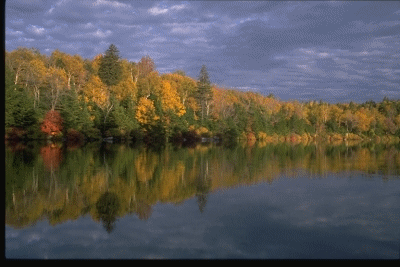
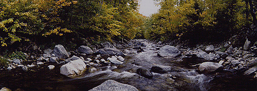
Wednesday, October 1, 2003 – Colonial Comfort Inn, Gorham, NH I spent the last few days packing and moving the last of my possessions out of the condominium on Glenbrook Road as it has been sold and will close while I am in New Hampshire. I turned in my rental car and walked to the Stamford train station where I caught the 8:46 AM to Boston. I had a five hour lay-over in Boston and tried to get together with Brad Ajello, but he was swamped with work and we were only able to talk on the phone. The bus to New Hampshire left at 5:10 PM and took just over four hours to get to Gorham, NH where I checked into the Colonial Comfort Inn for the night. Thursday, October 2, 2003 – IMP Shelter, AT, NH I stayed in the bunkhouse last night as the Colonial Comfort Inn had no rooms available. The fall foliage season is in full swing here in the northeast and finding places to stay on no or short notice is going to be a problem. I ate breakfast with Alan, a hiker from New Paltz, who I met on the bus from Boston yesterday and is hiking north. At 7:30 AM I went back to pack and was on the trail by 8:10 AM. The first part of the trail is 1 ˝ miles through the center of Gorham where I stopped to buy a knit hat. The only color they had was bright orange, which didn’t really go with any of my outfits, but the salesman recommended anyway as it is now hunting season and it will help distinguish me from the elk, moose, bear & deer. By 9:00 Am I was at the Carter Moraiah trailhead where I began the ascent of Mt. Morarih, one of New Hampshire’s 4000’ peaks. I had hoped to get to the hut at Carter Notch, a sixteen mile day, but as time wore on, and I realized I needed to find my hiking legs again, I changed my plans and stopped at the IMP shelter for the night. It was only 2:00 PM, but I spent the afternoon reading. In the early evening I was surprised to see snow falling and by morning a light dusting covered the mountains. Friday, October 3, 2003 – Carter Notch Hut, AT, NH I was awake at 5:00 AM, but the snow convinced me to stay in my sleeping bag until 7:30 AM. I finally got up, packed and headed out. The trail was slippery and it was surprisingly cold, but I had several layers of clothing and as long as I kept moving, I was OK. I climbed over The Carter Mountains, culminating with 4800’ Carter Dome. The view from Mt. Hight was spectacular with clear views of the Presidential Range. At 1:00 PM I started the steep 1500’ descent to Carter Notch Hut which is where I decided to stay tonight. The hut offers bunks and a communal kitchen and they charge $22 to stay there for the night. I warmed up in my sleeping bag for a couple hours, and then went to the kitchen hut to read for awhile. The hut manager, Heidi, offered me some hot chocolate which was delicious. At 6:30 PM I went back to my cabin where I read and then went to sleep. Saturday, October 4, 2003 – Pinkham Notch Lodge, AT, NH I slept until 7:00 Am and then got up, packed and went to the kitchen hut. Heidi was able to get me a reservation at Pinkham Notch Lodge during her 8:00 AM radio call which kept me from having to retreat to Gorham again for the night. The weather today calls for rain turning to snow at higher altitudes. The AT route from Carter Notch to Pinkham Notch goes over Wildcat Mountains and ends with a perilous 2000’ descent as it approaches Pinkham Notch. Since the guidebooks advised ‘extreme caution’ in good weather, I decided to forego this particular section and take the Nineteen Mile Trail down to Route 16, and then hitchhike five miles to the Pinkham Notch Lodge. I left Carter Notch Lodge at 8:00 AM and by 9:00 AM it was pouring rain. Today’s altered route was only four miles and it was all downhill. I reached Route 16 by 10:00 AM and by 10:30 AM had made it to the Pinkham Notch Lodge. The rooms were not available for occupancy yet, so I did some laundry and had an early lunch before getting into my room at 12:30 PM. The rain continued throughout the afternoon, but the forecast for tomorrow is better and the following day when I plan to be going over Mt. Washington is also good. Sunday, October 5, 2003 – Col between Mt Madison & Mt Adams, AT, NH I had breakfast and took my time packing. It was 9:30 AM before I checked out but I only planned to hike four miles today to Osgood Tent site so I was waiting for it to warm up a bit. The day was beautiful when I left and headed up the trail to Osgood. The terrain was not hilly at all and I reached my goal by noontime. It seemed silly to waste such a good hiking day so I headed up Mt. Madison with the intention of finding a place to stay someplace on top. Mt. Madison was a 3000’ climb over 2 ˝ miles and it became quite steep towards the summit. Above tree line, it was extremely windy and I could have easily been blown over if I were not careful. I reached the top of Mt. Madison at 3:00 PM and descended the other side to Madison Hut which is now closed for the winter. I decided to pitch my tent in the lee of the building, and was settled in for the night by 4:00 PM. The wind shook the tent all night and it was pelted with frozen snow. Once or twice I felt myself being lifted off the ground as the wind got underneath the tent and lifted it briefly. I did not sleep too well, but was glad I had used the time in the afternoon to ascend Madison instead of waiting for tomorrow. Monday, October 6, 2003 – AMC Highland Lodge, Crawford Notch, NH Today is overcast, but when I was packing to leave at 7:00 AM it was not snowing. As I left my campsite, I immediately took a wrong turn and the day went downhill from there. I was following signs for Mt. Adams, but then took a wrong turn onto The Buttress Trail and hiked downhill for ten minutes before turning around. I was able to turn left onto a blue-blazed trail (The AT is marked by white blazes, and blue blazes indicate an offshoot of the AT) which seemed to go steeply up what I thought was Mt. Adams, where I would rejoin the AT at the summit. This trail was very steep and near the top I was climbing with my arms as much as my legs. It had also begun to snow, the wind was howling and visibility was about 100’. The summit of Mt. Adams had a large sign indicating several trails going in different directions, but it was completely encrusted with ice and no amount of scraping with a rock enabled me to read the sign. I did meet two hikers who had come from, and were returning to Crag Camp. Crag Camp is north of Mt. Adams and the AT goes west to Mt. Washington, so against my better judgment, I headed down 90 degrees from the direction they had come up, even though I could see no trail or cairns. The trail above tree line, especially as it crosses piles of rock, is marked by cairns and, along today’s section yellow and/or white way markers. Since there are no trees, the way markers are painted on the rocks, which are covered with snow. The absence of cairns therefore was of great concern. I continued crisscrossing the mountainside for about an hour before deciding I should head back to pick up the trail to Crag Camp where I could reestablish my bearings. I found the trail at about the point I thought it would be and then located a new signpost which indicated the direction to Mt. Washington where I was headed. Even though the wind and snow were increasing, I felt much better to be back on track. Now as I write this and can look closely at a map, I realize that there are actually three different similarly named mountains; Mt. Adams, Mt. Quincy Adams and Mt. Samuel Adams – all within one square inch on my map. As I was standing atop Mt. Adams, I was reading the map as if I were atop Mt. Samuel Adams. It was five miles to the summit of Mt. Washington, but it took me almost five hours to get there. The visibility had dropped to about 75 feet and the cairns were spaced 50-100 feet apart. Not wanting to get lost again, I would walk to one cairn, and then make sure I could see the next one before heading out again. The trail only ascends 1000 feet between Mt. Adams and Mt. Washington but the terrain is extremely difficult as the entire route is over boulders and they were covered with snow. Oftentimes I would put my foot on a patch of snow, and sink in up to my knee, wedging by foot between the rocks below. I was the first, and probably only, person to travel this section of trail today so there were no other footprints to follow. As I got within a mile of the summit, I was soaking wet and decided that I would take the COG railway down Mt. Washington and stay at the AMC’s new Highland Lodge at Crawford Notch. The trail crosses the railroad tracks and I thought it might be easier to hike the grade of the tracks instead of continuing from cairn to cairn. This turned out to be another mistake because Cog railways ascend much steeper grades than normal, so I went back to the cairns, reaching the summit at 2:30 PM. The summit of Mt. Washington has a large tourist building with a restaurant, gift shop, observatory and weather station. The visibility was so poor that I was ten yards from the building before I actually saw it! I tried to buy a $49 round trip ticket for the cog railway, but they only sell round trip tickets at the bottom station and made me purchase 2 one-way tickets at $35 each to get down and back up the next day. I had some soup while I waited for the train, and then boarded for the 45 minute trip down the three miles of track. At the base, I hitchhiked the ten miles to Crawford Notch where I checked into the brand new AMC Highland Lodge. My room, which normally would accommodate two people but tonight I have for myself, is $50 which includes breakfast and dinner. I had just enough time for a shower before dinner was served at 6:00 PM. There are about 50 people here and I think the place can accommodate 120. The setting is very nice with mountains of fall colors surrounding it on all sides. I think I might have to stay here for two nights. Tuesday, October 7, 2003 – AMC Highland Lodge, Crawford Notch, NH I decided to take a ‘zero day’ today to enjoy the Highland Lodge. The facility is less than a month old, has a library, several sitting areas with comfortable furnishings and large fireplaces. There is no guest laundry or internet access, but I was able to wash some clothes in the sink and prevailed on the manager to allow me to use her computer to check my email. I ate breakfast, lunch and dinner at the lodge and actually only ventured outside once to walk 200 yards to the Crawford Notch train depot. I completed two books and exchanged them in the library for another. Tomorrow, I’ll take the Cog railway back to the top of Mt. Washington to pick up the trail where I left off. Wednesday, October 8, 2003 – Mizpah Spring Hut, AT, NH I ate breakfast and packed to check-out. The AMC shuttle took me from the Crawford train depot up to the base of the Cog railway for $10. I had to purchase another one-way ticket to the top of Mt. Washington even though I had tried to buy a round-trip ticket the other day. Another $35 for the 3 mile trip up the mountain. At least today it is beautiful and the summit is clearly visible, along with most of the train route up the mountainside. I reached the top after an hour and twenty minute ride. I took some pictures and was on my way by 11:00 AM. There is still snow on the trail, but it is melting. The trail is a stream in places and my boots quickly became soaked. I got to ‘Lake of the Clouds Hut’ after about an hour of hiking downhill. This hut is closed for the season, but it is in a spectacular setting and would be a wonderful place to stay at sometime in the future. My back was a little sore so I was not hiking too fast. The AT circumvents both Mt. Monroe and Mt. Eisenhower, but there are side trails that lead over the summits of both peaks. I passed on the peaks. At 3:15 PM, I reached Mizpah Springs Hut which can accommodate sixty hikers and has a staff of five. Aside from the staff, I am the only one here. I ate dinner with the staff as they talked of one of their favorite pastimes – racing the Cog railroad up the mountain. Thursday, October 9, 2003 – Zealand Springs Hut, AT, NH I was up early and packed before breakfast was served at 7:00 AM. The meals served at the huts are huge and are included in the $60 cost of staying there for the night. I had planned a long day today so I was hiking by 7:30 AM. I passed over Mt. Jackson and Mt. Webster, and then took the Webster Cliffs Trail down 2500 feet to Route 302. By noontime, I was going up the Willey Range Trail towards Ethan Pond. I saw several wild chickens on the trail which did not seem afraid of my presence. On one occasion, I actually had to shoo one off the trail so I wouldn’t step on it. The hike today was 13 miles, but it was not difficult. I reached the Zealand Hut at 3:00 PM and spent the rest of the afternoon reading. There are twelve other guests here tonight, including Heidi who is the hut manager at Carter Notch and was at Mizpah Hut last night as well. Friday, October 10, 2003 – Garfield Ridge Campsite, AT, NH We ate breakfast as a group at 7:30 AM. I packed and waited until 8:00 AM when there was a radio call during which I could find out if there was availability at Lonesome Lake Hut for Sunday & Monday nights. This being Columbus Day Weekend, there was not room so tomorrow I’ll hitchhike twelve miles north to Twin Meadow to see if I can find a place to stay there. I started hiking at 8:00 AM and immediately had to ascend Zealand Ridge. I caught up to a couple of guys from Pennsylvania whom I had met at the hut last night and we hiked together for a couple hours. I reached Galehead Hut at 1:30 PM and rested for an hour before continuing on to my destination for tonight – Garfield Ridge Campsite. Saturday, October 11, 2003 – AMC Highland Lodge, Crawford Notch, NH I was packed and hiking by 7:30 AM. Today is beautiful, but my excitement is contained by the steepness of the trail. The first task is to complete the ascent of Mt. Garfield, which I began yesterday afternoon. It is only 500 feet to the summit, but the trail is very steep and my thighs are burning by the time I reached the top. There are a couple miles of downhill after Mt. Garfield which leads to 5250 foot Mt. Lafayette. There are lots of people on the Garfield Ridge Trail leading to Mt. Lafayette and also on the Franconia Ridge Trail to Mt. Lincoln. Most people are day hikers who have come out for the holiday weekend or hiked up from Greenleaf Hut, two miles below Mt. Lafayette. I did not fill two of my three water bottles this morning as I did not want to carry the extra weight up hill. Now that I look at the map closely, however, I’ll be hiking along ridges for six miles with no opportunity to get any more water. Around 1:00 PM, I reached the Franconia Ridge Trail and started descending towards Route 93. I was very dehydrated when I reached the Liberty Springs Campsite and quickly drank two liters of water from the spring. Three miles later, I was at the base of Franconia Notch where I hitchhiked north to the town of Twin Mountain. The guys who gave me a ride dropped me off at a motel which was owned by a recently retired Connecticut State Trooper. Unfortunately, he did not have any rooms available, nor did any of the other half dozen motels he telephoned on my behalf. After a half hour of looking for a place to stay, he called the AMC Highland Lodge where I had stayed a few nights ago and they did have a place for me. The motel owner gave me a ride 20 miles back to Crawford Notch where I arrived just in time to shower and have dinner at 6:30 PM. Before going to sleep, I watched a movie on Katadhin. Sunday, October 12, 2003 – Carriage Motel, North Woodstock, NH The Highland Lodge was having it’s grand opening this weekend with many AMC directors and donors in attendance. Rain is forecast for the next few days so I planned to take a few days off from hiking, but the Highland Lodge is sold out for tonight so I had to find a different place to stay. I located a motel in North Woodstock, and then discovered the cab fare to get there was $50. Instead, I waited until 1:15 PM and took the regularly scheduled AMC shuttle which took me right to North Woodstock for $20. The ride over to Woodstock really allowed me to appreciate the fall colors which I think are more spectacular from the road than from high in the mountains. North Woodstock is a quaint little tourist town with restaurants, a laundry, internet access and several motels and inns. I purchased some food at a market and ate dinner in my room as I caught up on the news. Monday, October 13, 2003 – The Woodstock Inn, North Woodstock, NH I did some laundry this morning and then walked down to check out the Woodstock Inn, a wonderful little country inn I had discovered yesterday. I made arrangements to move here later today. I visited a number of shops in North Woodstock without buying anything. I had lunch at a small diner and then went back to The Carriage Motel to pack my stuff and move over to The Woodstock Inn. In the afternoon I emailed Al & Linda and made arrangements to meet them for dinner tonight at The Woodstock Inn. They are going to Ohio to run a marathon this weekend and are also considering the same Alpine Ascents trip to Ecuador’ volcanoes which I am taking in December. After dinner, I went back to my room to watch the baseball playoffs. Tuesday, October 14, 2003 – The Woodstock Inn, North Woodstock, NH I feel guilty today as it is a beautiful day and I am not hiking. Tomorrow it is suppose to rain all day so I’ll wait here until Thursday before I get back on the trail. The Woodstock Inn has a brewery in it’s pub and each morning they make a couple hundred gallons of beer which is either bottled for resale or pumped to kegs in the basement for use in their own restaurants. I ate breakfast and lunch at the inn, but skipped dinner to watch the baseball playoffs. The Inn has a guest computer which went down in the afternoon, but they were able to get it repaired so I could send my emails before the end of the day. The wind is really starting to howl now and I bet that when I wake up tomorrow, most of the leaves will have come down off the trees. Wednesday, October 15, 2003 – The Woodstock Inn, North Woodstock, NH It rained most of the day and the high winds continued. I ate breakfast and lunch again at the Inn, but skipped dinner. I left the Inn only once to purchase some food for the resumption of my hike tomorrow. A few days ago a ten year old boy disappeared while walking on a path only a few hundred yards from his family’s vacation home in Lincoln, NH – the next town over. Hundreds of volunteers have combed the woods looking for him and there has been significant coverage on local and national TV. Today the searchers found the boy’s body in dense forest about a mile from where he disappeared. He had died of exposure. Thursday, October 16, 2003 – Eliza Brook Campsite, AT, NH I was up and packed at 6:00 AM. I ate my final breakfast at The Woodstock Inn and then checked-out. I started hitchhiking the five miles north to the trailhead, but didn’t have much luck and before I knew it, I had walked the entire distance. I was back on the trail by 9:45 AM. At Lonesome Lake Hut I stopped for some hot chocolate, but quickly got restarted. I passed Kinsman Pond Campsite, went over North and South Kinsman Mountains and got to Eliza Brook Campsite around 4:00 PM. I am the only one here – as a matter of fact, I did not see any other person on the trail today at all! It is cold and during the last hour of hiking it was snowing. The trail has become very slippery and I need to use extreme care so as not to fall. Friday, October 17, 2003 – Carriage Motel, North Woodstock, NH Three hikers came into the Eliza Brook Shelter last night so I wasn’t alone after all. I had turned in for the night by the time they arrived so I didn’t spend much time socializing. I left the shelter at 7:20 AM and headed up over Mt. Wolf. I had originally planned to hike about nine miles to Beaver Brook Shelter on the slopes of Mt. Moosilauke, but the trail was very wet and my boots were soaked. I decided to stop a mile short of my goal and find a motel on Route 112 to dry out for the night. While hitchhiking, I got picked up by a woman who know the area and she told me the nearest motels were in North Woodstock and she was going right through it. I ended up back at The Carriage Motel where I had stayed earlier in the week. I did some laundry, had lunch at the Woodstock Inn, checked email there and then returned to my room for the night. I made arrangements for a shuttle service to pick me up tomorrow morning and take me back to the trailhead where I’ll hike over Mt. Moosilauke tomorrow. Saturday, October 18, 2003 – Warren Village Inn, Warren, NH I didn’t sleep too well last night and was up at 4:00 AM. I watched TV for awhile and got coffee at the market across the street when it opened at 6:30 AM. I also had time to check email at The Woodstock Inn again before the shuttle service picked me up at 7:45 AM to take me to the trailhead. By 8:00 AM I had started climbing Mt. Moosilauke. There is a rather intimidating sign at the base of the mountain warning hikers that this particular trail is extremely difficult and should not be attempted by inexperienced hikers. The trail was very steep but there were steps in the stone and the greatest difficulty I encountered was circumventing the fallen trees, which blocked the trail. By 10:00 AM I had reached Beaver Brook Shelter and took a short break while visiting with five people who had slept there last night. The climbing got easier as I passed over the summit of Mt. Blue and continued on to Mt. Moosilauke which, at 4800 feet, is the last of the 4000 footers I’ll have to climb in New Hampshire. I was surprised to see almost three dozen people on the summit when I arrived at noon. I had planned to take some pictures when I got to the top, but just as I arrived, the wind blew in a cloud bank and visibility dropped to 100 feet. The trip down was an easier grade than the way up, but as such, it was longer. It was over five miles to Glencliff where the trail intersects Route 25. I went to the ‘Hikers Welcome’ hostel where I had planned to spend the night, but it was such a dive I decided to continue down to Warren where I checked into the Warren Village Inn for the night. The Warren Village Inn is a recently restored B&B with seven rooms owned by a CPA and his wife. I walked a half-mile back into town to pick up some groceries at the market and returned by 4:00 PM for the night. Sunday, October 19, 2003 – Warren Village Inn, Warren, NH Today it was suppose to rain and I had made arrangements to stay at this inn for a second night. Unfortunately, the rain never came and I felt guilty sitting around all day doing nothing. I walked to the town and spent about five minutes checking out everything of interest, and then returned to the inn where I read for most of the day. At night I watched the first six innings of the Yankee game, then went to sleep comfortably knowing that they were ahead and would most likely win. Tomorrow it is suppose to be very cold in the morning, but overall a beautiful day. If I leave early and hike all day, I should be able to go twenty miles. Monday, October 20, 2003 – Fire Warden’s Cabin, Smarts Mountain, AT, NH I was up and packed by 6:00 AM. The day looks pretty good for hiking although rain is predicted for tonight and tomorrow. I ate breakfast, and then the innkeeper gave me a ride five miles back to the trailhead in Glencliff where I left off the other day. I was hiking by 7:30 AM. There are four mountains to cross today, but none of them is too difficult. The sun sets at 6:00 PM so I’ll need to be at the summit of Smarts Mountain where I hope to stay in the Fire Warden’s Cabin by then to avoid hiking in darkness. The nice ting about the Fire Warden’s Cabin is that it is enclosed on all four sides and would be a better refuge if it rains tomorrow and I have to stay an extra day. It was cold but as long as I kept moving I was OK. I went over Mt. Mist and Ore Hill, both 2000-foot hills, and then in the afternoon climbed Mt. Cube and Smarts Mountain, both 3000 feet. I reached Fire Wardens Cabin at 5:30 PM and had the place to myself for the night. The cabin is well built and is both wind and watertight. Tuesday, October 21, 2003 – Fire Wardens Cabin, Smarts Mountain, AT, NH Today I awoke to a storm blowing outside and I decided to stay here for another night. It is not cold enough to snow, but the rain is pelting the cabin and there is thunder and lightening. Around noontime, there was a break in the storm and a couple girls passed by, making me feel a little guilty that I was taking the day off. My guilt was short lived, however, as the storm picked up again shortly after they had left. I read and slept most of the day and will try to hike thirteen miles tomorrow, rain or shine. Wednesday, October 22, 2003 – Dowds Country Inn, Lyme, NH I was hiking at 7:30 AM this morning and immediately found the trail to be very slippery. The first four miles were all downhill and I slipped and fell badly once. It started to snow on the way down and by the time I reached the first crossing of Lyme-Dorchester Road, I was soaking wet. I was surprised and happy to find a note on a tree from a friend whom I told that I would be hiking in this area. I continued hiking for another hour, passing a granite column indicating that I have hiked 412 miles from Katadhin, but still had 1702 miles to go before I reached the southern terminus in Georgia. When I got to the Dartmouth Skyway I decided to call it a day and got a lift into Lyme with a local carpenter. There are a couple nice inns in Lyme and after looking at them both, I decided to stay at Dowd’s Country Inn. The inn is right on the green, which makes up the middle of town, only a couple hundred yards from the library, which has a computer. I’m about 18 miles from Hanover and feel confident that I can get there in one day. The weather is questionable for tomorrow with some forecasts calling for 2-4 inches of snow. My hiking boots are about to fall apart and I’ll have to buy a new pair in Hanover. Dowd’s Country Inn has a warm living room with a fireplace and TV where I watched the fourth game of the World Series. Thursday, October 23, 2003 – Dowd’s Country Inn, Lyme, NH Today I woke up to find two inches of snow on the ground with more coming down. The innkeeper told me there was twice as much up in the hills. Needless to say, I decided to stay put for another day. I went to the library after breakfast and typed my journal for awhile and then returned to the inn and spent the afternoon reading. Tonight, I’ll watch the World Series. After looking at some maps, I’ve decided to hike to Hanover tomorrow on Route 10 if the weather is still bad. The road will cut about 8 miles off the not-so-straight trail route, but it will not be wet and slippery. One other problem I’ve just realized is that this is homecoming weekend at Dartmouth College in Hanover and I probably won’t be able to find anyplace to stay until I get well past the town.
Friday, October 24, 2003 – Happy Hill Shelter, AT, VT I was up and packed at 6:30 AM. I went downstairs to check the weather on TV and to confirm that the Yankees had lost last night’s game, which I was too tired to watch. The weather looked good, but since the trail through the woods would still be wet, I decided to hike on Route 10 as far as Hanover. I ate breakfast and was hiking at 7:30 AM. It was cold and there were occasional snow flurries but it seemed as if the sun would eventually come out. A couple of miles out of town I passed a turkey farm. As I walked past the pens, all the turkeys raced up to greet me. They all seemed to be pleading ‘Save us, save us’ as I hiked under a big sign advertising fresh turkey for Thanksgiving. I got to Hanover at 10:30 AM and the town was buzzing with activity. This weekend is Dartmouth’s Homecoming Weekend and there are many sporting and alumni activities planned. Students were building a 4-storey structure in the middle of the green, which will be lit on fire later tonight. I stopped at one of Dartmouth’s buildings where I could check email, and then continued my hike out of New Hampshire and into Vermont. In Norwich I ate lunch at a local market, and then checked next door at The Norwich Inn to see if there were any rooms available for the night. There were no rooms available and the innkeeper told me that everything for miles around was sold out. I decided to continue hiking up into the woods and stay at The Happy Hill Shelter, which I reached at 2:30 PM. Saturday, October 25, 2003 – Shire Motel, Woodstock, VT There is a great poem by Robert Service entitled ‘The Lure of Little Voices’ attached to the wall of the Happy Hill Shelter. I must remember to get a book of his poems as I’ve enjoyed everything I’ve read by him. I didn’t leave the shelter until 8:15 AM as I planned to go only nine miles to the next shelter. After three miles, I passed through a little town and stopped to have breakfast at the combination market/post office/diner/gas station. While there, I heard that heavy rain was predicted for tomorrow so I changed my plans and decided to go only as far as Woodstock, VT where I would stay until the rain passed. This meant that I’d have to hike to where the trail crosses South Pomfret Road…some thirteen miles. By the time I got there at 2:30 PM, my legs were pretty tired. I hitchhiked a ride to Woodstock with a local dentist who had recently moved here from Boston to open a practice in Hanover. He took me directly to the Shire Motel where I was able to check in for the night. I found the laundry mat, Internet Café and food market. After showering, I decided to stay in for the evening and explore the town tomorrow. Sunday, October 26, 2003 – The Woodstock Inn & Resort, Woodstock, VT I did some laundry early in the morning and then walked through the center of the village. Woodstock is the home of Laurence Rockefeller whose philanthropy and championship of natural preserves is renowned nationwide. I discovered a beautiful Inn (The Woodstock Inn and Resort, owned by Rockefeller) and decided I would move here for the next couple days. I returned to The Shire Motel to check out and by 11:00 AM had returned to check into the Woodstock Inn. My room was not ready so I enjoyed a wonderful Sunday Brunch at the Inn. As it turned out, brunch was my only meal of the day, although I’m sure I consumed enough for three meals at once. I spent the rest of the day reading in front of a huge fireplace at the Inn. Monday, October 27, 2003 – Woodstock Inn & Resort, Woodstock, VT Today it rained all day. I went out for breakfast, and then walked to the barbershop to get a haircut, but it was closed. On the way back to the Inn, I picked up some traveling food at the town market. I spent a couple hours at The Woodstock Public Library typing my journal and then returned to the Inn for afternoon tea. I skipped dinner because I was still full from the delicious homemade cookies served with the afternoon tea. Tuesday, October 28, 2003 – The Lookout, AT, VT I was up and packed by 6:00 AM. Breakfast did not open until 7:00 AM so I spent some time on the Internet before eating. Yesterday, I had confirmed that a taxi could pick me up at 7:30 AM to take me back to the trailhead, but today no one knew anything about it and the soonest a cab could get to the Inn was 9:00 AM. The Inn has a van, which could take me the five miles for $75, so I decided to walk. The town of Woodstock is not on the trail map I have so although I headed out of town in the right general direction, I took some wrong turns and did not reach the trailhead until 10:00 AM. The weather was beautiful though and walking through the backcountry roads of Vermont was picturesque. I planned to hike to a place, which I had heard about but was not an official AMC shelter. The owners of Lookout Farm have a cabin at the highest point of their property, which is near where the AT runs. Known as ‘The Lookout’ the cabin is enclosed on four sides and the owners allow hikers to stay there. It has a great view of the countryside. I reached ‘The Lookout’ at 3:30 PM. There is a fireplace here, but also a sign requesting no fires. I am the only person here so I spread out my all over the floor and read for an hour before having dinner and going to sleep. Wednesday, October 29, 2003 – The Lookout, AT, VT As forecast, it is raining today so it is nice to have a place to stay where I can stay dry. No one else came by today and I only left the cabin once to find some water. I read most of the day and went to sleep when the sun went down at 6:00 PM. Thursday, October 30, 2003 – The Inn at Long Trail, Killington, VT The sun came up at 6:00 AM and I was hiking within 30 minutes thereafter. It was cold, but the rain had passed. The trail was very wet. I wore three layers of clothing including a Gore-Tex rain suit. After a few hours, I was soaking wet with perspiration, but it was still too cold to take off the Gore-Tex. At 11:00 AM I stopped at Stony Brook Shelter and had lunch. I also changed my shirts and removed my Gore-Tex pants. I continued over Quinby Mountain and reached River Road by 1:00 PM. As I treaded up the next valley on Thundering Brook Road, I somehow missed the turn where the trail turns left off into the woods. Rather than retrace my steps for a half-mile, I saw that Thundering Brook Road loops around and crosses the trail again so I decided to continue on the road. This added about a mile to my day, but hiking the road was easier and there were no cars. According to my map, there was an icon for a motel at the end of Thundering Brook Road and I had planned to stay there for the night. When I arrived, however, it was closed for renovations. I continued on another mile to Route 100 where I hitchhiked south to Killington and checked into The Inn at Long Trail. I had heard a lot about this place and was looking forward to staying here. There is an Irish Pub on the premises and the Inn itself is right on the original Long Trail/Appalachian Trail before it was relocated a mile west in 1999. The Long Trail runs the length of Vermont from Canada to the Massachusetts border and takes 3-4 weeks to complete. From Killington south, the Long Trail and the Appalachian Trail are the same. My room has a fireplace, which came in handy to dry my boots. I was able to repair them with Shoe-Goo in Woodstock and think they’ll last until the end of this trip. While doing a load of laundry, I relaxed in the indoor hot tub. The pub opened at 4:00 PM and I had dinner at the bar with a couple of guys who were hiking the Long Trail. I had a hard time falling asleep and was up well past midnight watching TV. Friday, October 31, 2003 - The Inn at Long Trail, Killington, VT I was up early and went to the lounge to read before breakfast. At 7:00 AM there was coffee available and I ate at 7:30 AM. Today is a beautiful day and I was tempted to move on, but I had already mentally adjusted to the fact that I'd be here for two nights so I decided to slack pack a few miles instead. I didn't wear a jacket and put on running shoes instead of my hiking boots. I walked two miles on the road back to the place where the AT crosses Route 100, and then headed south up the mountain. Without my backpack, I sailed up the hill and actually ran portions of the trail. By 10:00 AM I had covered three miles of trail and three miles of road and was back at the Inn. I took a quick shower and then caught a bus to Rutland where I spent most of the day. I went to the library to use the computer and then had lunch at a little Italian restaurant. I spent an hour walking around downtown Rutland which seems to have an unusual number of churches. At 3:15 PM I took the bus back to the Inn. After catching up on the news, I went to the Inn's Irish pub for dinner. Saturday, November 1, 2003 - Governor Clement Shelter, AT, VT I was up and packed by 6:30 AM and had to wait an hour for breakfast to open. By the time I finished breakfast and checked-out, it had started to rain. The forecast had called for early morning showers so I decided to wait an hour before leaving to see if it would clear. The rain did stop and I was on the trail by 9:00 AM. I went up and over 4000 foot Little Killington Mountain and was hiking downhill by 12:30 PM. Throughout the afternoon, I heard gun shots from hunters in the forest. The temperature was cool but it did not rain anymore. I reached the Governor Clement Shelter at 2:30 PM and was excited to see it had a fireplace. I collected a bunch of wood and built a fire before realizing I couldn't light it because I could not find my lighter. So much for dry boots tomorrow. I had tuna fish for dinner and turned in hoping that another hiker would show up with matches - but it never happened. The Governor Clement Shelter is at the cross roads of the AT and a couple dirt roads. All night starting at 9:30 PM, I was kept awake by ATV's that would race up the dirt road and circle the shelter. They seemed to be very happy that there was someone trying to sleep that they could wake up. There were probably a half dozen incidents, the last one coming at 4:00 AM. It was not a good place to stay. Sunday, November 2, 2003 - Holiday Inn, Rutland, VT I left the shelter at 6:30 AM. I planned to hike thirteen miles to Route 140 and then hitchhike to Wallingford to stay in an Inn. The first few hours were fine, but then it started to rain. I considered stopping six miles short of my goal at Route 103, but the trail was generally downhill so I decided to keep going. At the Minerva Hinchley Shelter I met three local hikers who told me my experience with the ATV's last night has been an ongoing problem at that shelter. The last 3 1/2 miles of the trail as it descends to Route 140 has been relocated and extended by a half mile. I got to the road and hitchhiked into Wallingford. There were three B&B's in Wallingford - all closed. Even the library was closed for renovation. After fifteen minutes of walking around and not finding anyplace to stay, I saw the guy who had given me a ride into town and he offered to drive me up to Rutland where there were lots of motels. I went to the Rutland Library and checked email, and then called a few motels and discovered a Holiday Inn that offered to send a van to pick me up. After checking in, I had lunch in the restaurant, did some laundry and spent some time typing my journal. I had dinner at the Holiday Inn also and went to sleep early. Monday & Tuesday, November 3 & 4, 2003 - Holiday Inn, Rutland, VT It rained all day Monday and Tuesday. I was comfortable at the Holiday Inn so I took both days off. I spent my time reading, enjoying the health club, and surfing the web in the business center. Wednesday, November 5, 2003 - Weathervane Motel, Manchester, VT Today is another miserable day, but I couldn't possible spend any more time at the Holiday Inn so I packed up and left at 6:00 AM. I took a taxi back to Wallingford where I had left off on Sunday. Instead of hiking the AT towards Manchester, I decided to hike on the road which parallels the trail. The road was seventeen miles as opposed to twenty-six on the trail, but I could make it in one day and wouldn't have to worry about slipping in the woods. There was an old railroad line that ran a hundred yards from the road which I walked on because it was safer and more enjoyable than the asphalt. After about eight miles though, I came to a bulk chemical depot and the tracks took on a much more active appearance, so I went back to the road. Route 7 is a two lane highway for most of the seventeen miles to Manchester and there were no services or restaurants whatsoever. The rain really started coming down hard in East Doset so I decided to hitchhike the last four miles. The couple who picked me up were from Wilton, CT and they gave me a quick tour of Manchester before dropping me off at the library. After checking email, I had lunch at a pub, and then went to The Weathervane Motel where I checked-in for the night. Thursday, November 6, 2003 - Stratton Pond Shelter, AT, VT Finally a good day for hiking! I was up and in a taxi at 7:00 AM to go back to the trail head. We stopped for coffee and then headed up Route 30. The terrain was relatively flat today and I covered the ten miles to the base of Stratton Mountain by 12:30 PM. The Stratton Pond Shelter is new and has bunks and a picnic table. I had bought a new lighter and was looking forward to making a fire, but there was a sign prohibiting fires, probably due to the proximity to the privately owned ski mountain. One other hiker passed through in the afternoon and told me he had seen a moose earlier in the day. Friday, November 7, 2003 - Caughnawaga Shelter, AT, VT Rain woke me up at 4:00 AM. The forecast was suppose to be good and I had planned to hike fifteen miles today. I lay awake for a couple hours, and then packed and left at 6:30 AM. The rain had stopped, but the trail was slippery. I went up and over Stratton Mountain - three miles up and three miles down. At 9:00 AM the sun burned through the clouds and it seems that this will be a nice day after all. I stopped for lunch at Story Spring Shelter and then quickly continued on to my final destination - Caughnawaga Shelter. I tried to build a fire but all the wood was wet and I was unsuccessful. Instead, to dry out my boots and clothing, I brought it all into my sleeping bag to dry it out overnight with body heat. Saturday, November 8, 2003 - Kirkside Motor Lodge, Bennington, VT I woke up at 4:30 AM and discovered that the water in my bottles was frozen. It was very cold and the wind was howling. I brought my water bottles into my sleeping bag with my clothing and boots. At 6:00 AM it seemed colder, but I had a long day ahead of me so I dragged myself out of my sleeping bag, packed up and left. I wore three layers of clothing including my Gore-Tex bibs and jacket to shield me from the wind. The sun eventually came up, but it remained cold and windy throughout the day. The terrain was mostly downhill and the fifteen miles to Route 9 went quicker than I thought. One unanticipated benefit of the cold weather was that the ground was frozen and I did not have to worry about muddy trails. I reached Route 9 at 1:00 Pm and hitchhiked five miles into Bennington. I found a small motel and then went to the library. I emailed my Aunt & Uncle in Albany to arrange to meet them for lunch Monday when I finish. I had a great lunch/dinner at a restaurant and then returned to my room to do laundry and sleep. Sunday, November 9, 2003 - Porches Inn, North Adams, MA I was packed by 6:15 AM. I had requested that a taxi pick me up at 6:30 AM to take me back up to the trailhead. Today I would have to hike 20 miles in order to finish this section before the snow that is predicted for tomorrow. After a steep 1000 foot climb at the start, the trail leveled off. It was very cold but the ground was frozen and the travel was easy. I took a break at the six mile point and then stopped again at eleven miles for lunch. At 1:00 PM I reached the Vermont - Massachusetts border, and then continued an additional four miles down East Mountain to the road. This was the end of this section of the AT. I didn't have any luck hitchhiking into North Adams and ended up walking the two miles to town where I checked into The Porches Inn. The Porches is a beautiful new inn across from Mass MoCa, a contemporary art museum which has been created out of the old Sprague Electric Company factory. It has a pool, hot tub, health club, Internet service and very comfortable beds. I ate four freshly baked cookies during the time it took to check-in. Tomorrow I scheduled a massage in the morning and then plan to have lunch with my Aunt & Uncle at a restaurant in Williamstown. This completes my hike of the New Hampshire & Vermont sections of the Appalachian Trail. I'll return next year to pick up where I left off and hopefully complete the trail to Georgia. Tuesday I'll take a bus back to Connecticut where I'll spend a few days organizing stuff for my next trip. Next week I'm going to Miami for a few weeks before leaving for South America in mid-December. | Back | Map | Home | |