After
getting little sleep on the airplane Saturday night, I got no sleep my first
night in the woods. At 5:30AM I
decided it was useless to keep laying in my sleeping bag so I got up, packed
in the dark and went down to the stream to fill my water bottles.
At 6:10AM it was light enough to see the trail so I headed out on my
7-mile ascent of 2,000-ft Humpback Mountain.
Climbing was much more difficult than my relatively easy flat hike
yesterday. Furthermore I had
planned to hike 13.6 miles today so it turned into a very long day.
In the early afternoon the three guys I had spent last night with
passed me on their way to “The Priest” – a 4,000-ft mountain I will need to
climb in a couple days. At
3:30PM, I reached my goal…the Three Ridges Overlook on the Blue Ridge
Parkway. I had arranged for
Keith, the proprietor of the Royal Oaks Cabins in nearby Love, VA to pick me
up here and take me to his facility for the night.
I was able to wash my clothes, all of which I had worn and were
dripping with sweat, and buy a sandwich and a bottle of orange juice from
his camp store.
I slept
very well Monday night and although I had considered the possibility of
taking a second day off to recuperate, I woke up Tuesday refreshed and
decided to push on. Keith’s
cousin Frank (who delivers 5th wheel trailers all over the
country for a living) gave a ride back out to the trail where I had stopped
yesterday and I continued south.
Today was supposed to be an easy 8.4-mile hike to Harper’s Creek
Shelter, but I had to get over the North Ridge of the Three Ridges and the
trail was steep and rocky. I
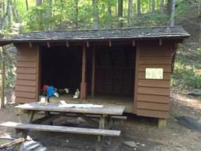
took my time resting in several places and finally reached the shelter
around 4:30PM. Since I had not
started until 10:00AM today, I guess that is not too bad.
Wednesday I was up early, packed and on the trail by 6:45AM.
I did not sleep very well last night either but managed to get in a
couple hours sleep before dawn.
Today I have a mile uphill, two miles downhill
I
continued on another mile where I spread out my gear at The Priest Shelter
where I planned to spend Wednesday night.
I gathered some wood to make a fire, but it was not dry enough to
burn so I decided I would do without a fire and leave the wood for another
hiker. No other hikers joined
me this evening. I had another
restless night, but seem to be getting used to the sounds of the forest at
night. Falling tree limbs make
the most noise, followed by falling acorns and cicadas.
I always wonder if a bear might be close.
I have not seen any, but have no doubts that they have seen me.
I sleep with my headlamp on and my hiking poles nearby, but so far
all is well.
Thursday
I planned to be a short day. I
had made a reservation at the Montebello Camping and Fishing Resort in
Montebello, VA which was only four miles south on the AT, but required an
additional four mile detour (two miles each way) down a steep ravine to
reach. I passed the Virginia State Fish Hatchery on my way down the mountain
to the resort. I had originally
asked for an efficiency cabin, but when I learned it did not have a
bathroom, I upgraded to a bigger cabin.
Arriving
at 11:00AM, I went to the country store to check in and bought some food.
My cabin has a full kitchen so I was able to purchase food that
required cooking. One of the
maintenance men gave me a ride up to my cabin where I unpacked.
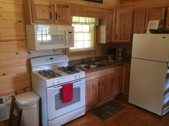
What a great place this is.
The cabin is only a year old and made of knotty pine.
There is a kitchen, bathroom, bedroom, loft with two additional beds
and a large veranda. The porch
looks out over a large grassy area.
People usually come here to fish in the resort’s private lake.
No license is required and it is free to fish, however, you must keep
everything you catch and pay $4.29/pound for the fish.
I washed my clothes and had noodles and a chicken sandwich for lunch.
There is no cell service here and no cable TV, but they do have DVD’s
for rent.
Friday,
August 28th I packed my gear after a restful night at The
Montebello Camping and Fishing Resort and headed over to the office to check
out. I returned the DVD I
rented last night and had a cup of coffee while I waited to see if someone
would come in who might be able to give me a ride back up as far as the fish
hatchery. After 20 minutes no
one showed up, so I decided to walk.
It is a 2-mile hike just to get back up to the trail where I left off
yesterday, but the good night’s sleep was worth the extra effort.
I had planned to be back on the AT by 10:00AM, but actually got there
an hour earlier. Today I will
hike 12.5 miles to the Cow Camp Shelter, but with the extra side trails, it
will be almost 15 total.
Today’s
hike is not too steep. There
are no elevation gains or losses more than 700-feet, but there are a lot of
them. In the afternoon I
reached a series of small mountains which had been cleared of forest and
were now pastures which had recently been mowed.
There were also old apple trees along the way which made me think
this used to be an orchard at one time.
I stopped and picked six apples which were bitter but juicy.
I arrived at the blue-blazed trail down to the shelter at 4:15 and
still had a half-mile to hike to the shelter itself.
I stopped at a stream to get water and then unpacked my gear and
spread out my sleeping bag. I
had purchased a sandwich at the country store this morning which became a
luxurious dinner along with stream water flavored with berry flavoring.
No one else is in the shelter tonight although it is still early and
there could be weekenders who come out later.
After
settling in for the night at 7:00PM, I heard footsteps and met Andrea and
Milo who had just hiked up from Route 60 and are heading north for a couple
weeks. We spoke for 15 minutes
and I discovered that Andrea works as a camp counselor for a non-profit
organization in North Carolina.
It will be good to have her and Milo (her dog) in the camp tonight.
I was up
early Saturday and hiking by 6:30AM.
After retracing the half-mile walk back up to the trail, I still had
to climb Bald Knob before the 5-mile descent to Route 60.
Today I planned to hike 14.6 miles and there were some steep ascents
in the afternoon. I had made
arrangements for a local taxi service to pick me up at 3:30PM so I kept
going most of the day to meet the deadline.
My legs really started hurting the last few miles but I made it to
the pickup location by 3:00PM.
I waited 40 minutes but the taxi never showed up.
I was on a fire road deep in the forest so when a pickup truck pulled
up and asked me directions to Buena Vista, I was more than happy to show
them. The couple was looking
for a place to go rafting and had all kinds of camping and rafting gear in
the back of the truck. I
nestled myself amongst the supplies and we took off down the mountain at a
frightening speed for a dirt road.
After 20 minutes, we came to an abrupt stop.
Here, in the middle of nowhere, were six police cars with lights
flashing. They had just
arrested a DUI and impounded his vehicle.
As we waited for the road to clear, the police decided they should
check the drivers ID and gun permit.
Fortunately he passed their tests and we continued another few miles
where he dropped me off at the Budget Inn where I wanted to stay.
I gave him $20 gas money which pleased him very much.
Monday
morning I had breakfast at Burger King.
Gary picked me up at 7:15AM and took me back to the trail where I had
stopped on Saturday. He charged
me $15 for the 20 mile, one-way ride.
I hiked uphill for two miles to Bluff Mountain and the rest of my day
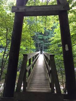
followed a ridge line to Big Rocky Row and then downhill to the James River.
The James is a couple hundred yards wide at this point and the
Appalachian Trail Conservatory has built a private footbridge which crosses
the river. I continued on the
opposite shore parallel to the river looking for an easy place to take a dip
in the river. Eventually,
however, the trail ascended away from the water and I arrived at Matts Creek
Shelter at 3:00PM where I would spend the night.
At
4:00PM, a group of 15 hikers arrived for the night.
They are from Washington and Lee University and this is a freshman
orientation trip involving four nights of camping.
They selected a group campsite somewhat removed from the shelter
where I was staying and set up their tents and cooked dinner.
About 8:00PM, one of the campers came to the shelter and asked if
they could store all their food in the shelter to protect it from bears.
Since I was sleeping in the shelter and did not want their food to
attract bears I told them I did not want them to store it here and they
should hang if from trees. She
grumbled that there were no suitable trees available and went away.
I slept OK, but woke up at 4:30AM.
I packed and waited two hours for it to be light enough to hike.
Just before leaving I went up to the latrine and found it full of
food. The door had been locked
from the outside, but even a small bear could easily have ripped the door
off the privy had there been one in the area last night.
Tuesday
I had a big all-day hike uphill.
I hiked up 3,700 feet over 12.7 miles.
Along the way I encountered a hunting dog that began to follow me.
Assuming I would encounter its owner sooner or later, I kept hiking
with the dog in tow. The dog
had two radio collars and when I checked closely I saw a phone number.
I called the owner and made arrangements to meet a couple miles up
the trail at a fire road to return the dog.
I
reached Blue Ridge Parkway mile marker 76.3 where I had arranged to meet
Gary Serra and get a ride back to Buena Vista for the night.
I checked back into the Budget Inn, did my laundry and was eating at
Subway when it started to rain.
I have had perfect weather until now.
The rain, however, was short lived, but I was glad to be off the
trail tonight.
Gary
picked me up again Wednesday, September 2nd at 7:30AM and drove
me 40 minutes back to the trailhead.
By 8:15AM I was southbound again, hiking uphill for the first mile
and then continuing for nine more miles to Bryant Ridge Shelter.
The possibility of rain continues today so I want to be at the
shelter by early afternoon. I
arrived at 1:45PM, changed my clothes and went down to the stream where I
struggled to get water from a very small trickle.
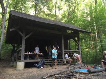
In the
afternoon, another group of freshmen from Washington & Lee University came
to the shelter for the night.
This is the third group I have met and I learned that there are actually ten
groups of 12-15 campers who are on 4-night hikes on the AT this week before
school starts. Thunder started
at 4:30PM so the group quickly cooked dinner and then came into the shelter
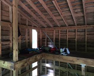
for the evening. This shelter
is much larger than most and with three levels, can easily accommodate 20
people. They played a game
called “Never have I ever…” followed by something they have never done.
Most of the responses were sexual and it seemed like a quick way for
a group of freshmen to get to know one another.
The
Wattstull Inn is quite far from the AT crossing on Route 43.
It is perched up on a hill with a nice view of the valley and
mountains. The owner checked me
in, I did some laundry and then since the inn’s restaurant is currently
closed, the owner lent me his truck to drive into town to get something to
eat.
I
watched some of the US Open and planned the remainder of my trip when I
returned from dinner. It looks
like I will hike for four more days, averaging 10-miles per day and then
stop at Route 311 where I will ask Gary Serra to pick me up and take me to
Roanoke, from where I will fly home.
Friday,
September 4th I awoke very early and went to the office to get
some coffee. The hotel
proprietor had promised to take me back up to the trailhead, but he did not
come in until 9:30AM. I waited
around the office for a couple hours to see if I could entice a ride out of
someone else, but no one came by whom I could ask for a ride.
At 9:45AM the owner took me back up Route 43 to the trailhead.
There was a large group of Washington and Lee hikers there, some of
whom I knew so we spoke for a few minutes before I started hiking.
Then as I ascended the switchbacks up the mountain, I immediately ran
into the guy who had picked me up hitchhiking yesterday who was out for a
day hike.
The
trail is quite gentle today but there is a 40% chance of thundershowers
starting at 2:00PM. I was upset
that I could not have started today earlier and was sure I would be caught
in the rain before I reached Wilson Creek Shelter.
Hiking as quickly as I could, I was able to cover the 10 miles in
five hours arriving at the shelter at 3:00PM.
The rain had held off…for the moment.
There
was one other couple at the shelter with a big German Shepard when I
arrived. Within an hour, a
second hiker, also with a big German Shepard arrived and the dogs went
crazy. But after their owners
separated them, things calmed down and the dogs were quiet.
I am sure the altercation cleared out any bears within several miles
of the shelter. The sky was
darkening and several more hikers came to the shelter and suddenly
lightening lit up the sky followed immediately by ear-piercing thunder.
Torrential rain poured down and lightening continued all around us.
Since I was one of the first to the shelter, I had a dry position in
my sleeping bag away from the rain.
The storm lasted less than an hour.
I awoke
early Saturday, packed up and headed out before anyone else was awake.
There are a couple of big climbs today but the hike is only 11 miles
so I was able to reach Route 220 by 1:30PM where I checked into the Howard
Johnson’s motel. I swam in the
pool, did some laundry and walked across the street for lunch at Pizza Hut.
The motel has a computer so I checked email and learned that my Aunt
Jen had passed away this morning in upstate New York.
I last visited here several years ago when Ying and my parents were
on a trip back East.
I also
used the Internet to arrange my flight home.
When I had looked a few days ago, there was a flight that would take
me from Roanoke to Sacramento for $270 one-way.
However, I did not book it at that time and now, to my amazement, the
cheapest flight is $800 one-way and it requires changing planes twice.
I called Gary Serra and arranged for him to pick me up at Route 311
at 2:30PM on Monday and take me down to a motel near the airport in Roanoke
where I will spend the night and then fly home on Tuesday.
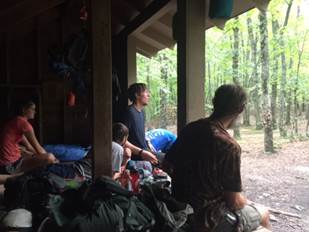
I
reached Lamberts Mountain Shelter by 3:00PM where I planned to spend the
night. There were three other
hikers here when I arrived, but they were just taking a break and planned to
hike an additional six miles south to Campbell Shelter.
Signs posted at Lamberts Shelter indicate recent bear activity so I
took what food, toothpaste and other items bears might find interesting and
slung them from a high branch of a nearby tree.
I found a deck of cards in the shelter and played solitaire until it
started to get dark and then turned in for the night.
An hour later, another hiker arrived who planned to sleep here and we
spoke for a while he unpacked and ate dinner.
Monday,
September 7th is Labor Day and my last day on the trail.
I was up and hiking by 6:30AM.
Today there are two big climbs; the first up Tinker Cliffs with a
great view of surrounding valleys and the second up McAfee Knob, a steep
thousand foot ascent. At the
summit of McAfee Knob, I called Gary and moved our pick-up time up by an
hour. As it was a holiday,
there were hundreds of people climbing up McAfee Knob from the south,
meaning I would pass them all on my way down.
Many folks were not carrying water for this 8-mile round trip which I
thought unusual or even dumb as I was easily consuming two gallons a day.
I reached the parking lot at Route 311 at exactly 1:00PM where Gary,
as reliable as ever, was waiting to take me to town.
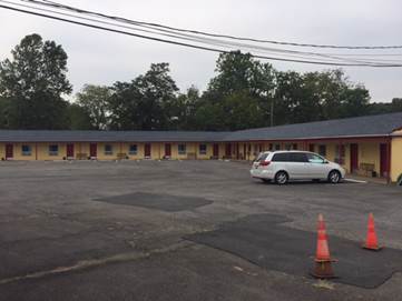
I went to the Airport Lodge, a somewhat sleazy motel, but several
rungs better than a shelter in the woods.
I swam, did laundry and then walked a mile to a local steakhouse
where I had the best meal I have eaten in two weeks.
Tuesday
I took a series of flights from Roanoke, VA to Charlotte, NC to Washington,
DC to San Francisco, CA, arriving home at 10:30PM.
I have completed all but the final 700 miles of the AT and plan to
complete that during the next few years.
| Back | Map | Home | |