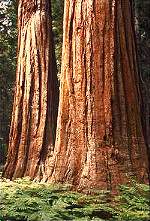
Monday, September 1, 2003 – Wuksachi Lodge, Sequoia National Park, CA I flew to California a week ago and spent time visiting family and planning a camping and hiking trip to three of California’s National Parks. Lauraine hosted a birthday party for Carolyn & Dad at her house where I was able to see most of the family. On Sunday I took Mom & Dad to the airport for their flight to Switzerland and then returned and met Lauraine and her friend for Chinese food at a local restaurant. This morning, I drove five hours south to Sequoia National Park, just east of Fresno, where I arrived in time to finalize my plans with a park ranger. I stopped to visit The General Sherman (giant sequoia) Tree, at an estimated 2.7 million pounds, the world’s largest living thing. At 5:00 PM, I drove to The Wuksachi Lodge where I checked in and ate dinner. Tomorrow I’ll pick up my backcountry permit at 7:00 AM. I also rented a mandatory bear-proof food container in which to keep food, although I’m carrying little food, I understand bears are attracted to anything with an odor (suntan lotion, toothpaste, deodorant etc). Bears are supposed to be very active now and there are also warnings about mountain lions. Tuesday, September 2, 2003 – Bearpaw Meadow Campsite, Sequoia National Park, CA
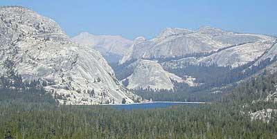
The day is beautiful. It is 60 degrees at 8:00 AM as I start the first eleven-mile section of what will be a five-day hike. The trail hugs the north side of a ridge and is mostly flat – the gain in elevation over the entire eleven-mile section is only 1000 feet. The elevation at the trailhead is about 6000 feet. I met one other hiker going in my direction at the trailhead and about a dozen people coming back in the opposite direction. My first wildlife encounter was right in the middle of the trail and I almost stepped on it. A small orange, yellow and black snake had captured a lizard and was in the process of strangling it. I watched and filmed for a few minutes until the snake finally released the lizard and proceeded to swallow it headfirst. At 11:00 AM, I rounded a corner and came across a small bear 20 feet away walking towards me. Although I had my camera at the ready, I spent precious moments deciding if I should be filming or running. When the bear turned to run, I decided it was safe to film, but may have waited too long. I never saw the bear again, but hopefully there will be others. Just before 2:00 PM I got to the Bearpaw Meadow Campsite and set up my tent. So far, I am the only one here, but it is still early. The site is very nice and there are metal bear boxes in which people can store food. There is a lot of chopped wood here, but I don’t plan to have a fire. After resting for a couple hours, I got up to explore the campsite. There was a deer outside my tent and he seemed to want to hang around as I took photographs. I heard thunder in the distance which became louder and louder. Another hiker came to the campsite and I found he is on a ten-day hike to Mt. Whitney (14,400’) the tallest mountain in the continental United States. By 4:30 PM it had started to rain. The thunder is deafening as it echoes against the granite canyons. I’m worried about lightening – the campground is amongst huge lodgepole pines, some 200 feet tall. My tent also has metal supports so I am sitting as close to the center as possible. The storm lasted until 6:00 PM and then moved on down the valley. About this time a mule train passed through the camp en route to Redwood Meadow Grove. The National Park Service uses mules to supply the outlaying ranger stations. Wednesday, September 3, 2003 – High Sierra Trail south of Kaweah Gap, CA I was up and hiking at 7:11 AM. The thunder had continued through the night making it impossible to sleep. Within half a mile, I came across the Bearpaw High Sierra Camp where there are 6 permanent tents that hikers can reserve 5-6 months in advance and also get their meals cooked for them. The cost of staying there is $175/person/night! The trail continued level for a couple of miles and then dipped down into a ravine where I crossed a bridge and started the long slog up to Kaweah Gap, 3500 feet above me. The altitude and lack of food was having a greater impact on me than I had planned. I frequently took 5-minute breaks. At 9:15 AM I reached Hamilton Lakes where I stopped and talked to a ranger for a few minutes. She thought my plan to go to Little Five Lakes today was a little ambitious and told me of another place to camp a few miles short of my goal. The trail got steeper after Hamilton Lakes and I slowed down considerably. Half way up to the Gap, it started to rain, and then the thunder came. There was no other choice than to keep going up the exposed rock face. A few hundred feet from the top, I found shelter under a large rock overhang with three other hikers who happened to be from Connecticut. After a half hour, the rain had not let up so I decided to keep going over the top and then find a place to camp on the other side. I passed over Kaweah Gap just after 1:00 PM and continued down into the valley below. I was hiking downhill now and felt better, but the rain persisted and I started looking for a place to camp. I’m about five miles short of my goal of Little Five Lakes and now believe the rains will add an extra day to my hike. Good thing I brought an extra energy bar! Of course as soon as I set up my tent and got into my sleeping bag, the rain stopped. But I was dry and happy with my progress so far so I’ll begin again tomorrow. Thursday, September 4, 2003 – Pinto Pond Campsite, Sequoia National Park, CA It rained on and off during the night, but it was clear when I got up. I packed and was hiking at 7:03 AM. The first two miles were downhill to the point where the trail divides. I left the High Sierra Trail here and started uphill to Little Five Lakes. The climb to Little Five Lakes was 2.9 miles and then I had an even steeper climb for the next 2.3 miles up to Black Rock Pass. At 11,600 feet, this is the highest point I will reach on this trip. One of the nice things about the trails here is the fact that they are graded so that horses can navigate them. This doesn’t make the climbing any easier because with the addition of switchbacks, the trails can be much longer than they appear on a map. I met a ranger at Little Five Lakes who told me to expect thundershowers again this afternoon. I picked out a place on the map where I thought I could be by 2:00 PM and planned to camp there. After much effort and several rest stops, I reached Black Rock Pass at 12:15 PM. From here, the trail drops 1500 feet to a broad valley where my campsite is near Pinto Pond. It took almost two hours to descend from the pass, and right on schedule, it started to rain. I got my tent set up and took shelter, but the rain didn’t continue and I was able to get out and walk around. I am the only one here in the valley. Friday, September 5, 2003 – High Sierra Trail six miles west of Bearpaw Meadow, CA Finally, a night without rainfall. I still did not get much sleep. I was packed and hiking by 6:36 AM. It looked like the trail was going to be downhill which was fine by me. After a few miles I reached the cut-off to Mineral King, but kept going straight towards Redwood Meadow Grove. A large bird sitting in the brush, just two feet off the trail, surprised me. It looked like an eagle or large hawk, but I’ve never heard of one sitting on the forest floor. Then I thought it could be an owl, but when I asked a ranger about it later, he thought it was an eagle that had just consumed something. The trail continued downhill, but at this point it became bad news because I knew that Bearpaw Meadow, where I had stayed a few days ago and I had to pass through again today, was at 2300 meters. I had now descended to 1800 meters, which meant I had a 500-meter climb ahead. Redwood Meadow Grove is a ranger station with a coral to keep the mules the park service uses to transport goods to various outposts. There were no mules when I passed through. Just beyond, however, the trail passes through a valley of giant sequoias and it was nice to walk silently among these huge titans of the forest. Every so often, I would hear a pinecone crashing through the limbs, but the trees are so tall that there was always time to look up and get out of the way if necessary. Some of the pinecones on the forest floor are over a foot long. At 12:15 PM I had completed the climb back up to Bearpaw Meadow where I rested for awhile. I was originally going to stay here again tonight, but it was early and since no rain was predicted, I decided to press on and make tomorrows hike shorter. At Buck Canyon, I saw a nice place to swim and although the water was cold, I happily washed four days of sweat off my body. I dried myself on the granite slabs, which had been absorbing the sun’s heat all morning and were nice and warm. At 1:30 PM I continued on and, although refreshed, I was very tired and the going was slow. My plan of just eating one 220-calorie energy bar per day was catching up with me. I passed about a dozen hikers coming into the section I was leaving – probably weekend hikers. I passed by a marmot sitting on a rock and could have petted it as I walked past. I must have developed a cold because I have been sneezing and have congestion. Then, all of a sudden, I was sick to my stomach. I rested again for a while, and then slowly continued on the final 4 miles to a campsite above Sevenmile Hill. The campsites are hidden on a mountainside and as I hiked up, I discovered that the lower sites were already taken and I had to climb 100 meters before I found a place I could stay for the night. Today I hiked 17 miles. Saturday, September 6, 2003 – Cedar Grove Lodge, King’s Canyon National Park, CA Last night, for the fourth night in a row, I could not sleep. I’ll have to check with a doctor when I get back to see if lack of food affects sleep. It seems strange that I can expend so much energy during the day, and still not be able to sleep at night. I was anxious to get back to civilization (and food) so I was on the trail at 6:35 AM, my earliest time to date. I had less than six miles back to Crescent Meadow where I had parked on Tuesday, and I covered it in 2 ˝ hours. I drove to the Lodgepole Visitors Center where I did some laundry and had 2 cups of coffee and two pancakes, which filled me up. I called to make reservations at the Cedar Grove Lodge in King’s Canyon National Park for tonight and tomorrow night and then drove the small winding road 1 ˝ hours north to the lodge. I plan to rest here until Monday when I’ll start another weeklong hike in King’s Canyon. Sunday, September 7, 2003 – Cedar Grove Lodge, King’s Canyon National Park, CA Finally, I slept last night. I think it may be the altitude that was affecting my sleep because the lodge here in the canyon is at least a mile and in a couple cases two miles below where I’ve been staying for the last few nights. I’ve heard this canyon is hundreds of feet deeper than The Grand Canyon! Of course, a soft bed and regular food may have helped also. I had to move to a different room today, but first I realized I was low on iodine tablets and had run out of Crystal-Light, which I use to flavor the treated water. Although there are markets here in the park, none of them seemed to carry these items, so I had to drive to Fresno (73 miles west) to buy supplies. I stopped along the way for breakfast, and then continued through the orange orchards of Sunkist which go on for miles. I picked-up the items I needed, along with a couple of James Patterson novels for the trail. I was back by noon to change rooms. The lodge laid-off 14 of 20 employees this morning due to the drop-off in business after Labor Day so the service is slow at best. There are not too many guests and most of them are outside enjoying the nice weather, but I am content to sit in my air conditioned room on a real mattress knowing that I’ll experience plenty of outdoors during the next week. In addition to one Slim-Fast Energy Bar per day, I have added three ounces of tuna fish and five ounces of trail mix. Hopefully, this extra food will keep me from getting as tired as I did last week in Sequoia. I’ve also got eight days of food for what I think will be a seven-day hike. I originally thought the extra foodstuffs would require carrying more TP, but then I realized I could use the already read portions of the Patterson novels instead. It’s amazing how creative you can be when you have to carry everything you need around on your back! The lodge lost phone service in the afternoon, but the manager let me use his personal line to complete sending my emails. I had dinner in the snack bar at 7:30 PM and learned from another hiker who had just come in off the trail that someone had spotted a mountain lion in the area where I’m headed a few days ago, so that is something to look out for. At night, I finished one of the two novels I had bought to take on my trip tomorrow. Monday, September 8, 2003 – Upper Paradise Valley Campsite, King’s Canyon NP, CA I got up early and charged the batteries of my cameras. I had breakfast in the snack bar and checked out of the hotel. The trailhead is about ten miles east at the end of route 180. I filled out the trail form and paid the voluntary $15 fee for the backcountry camping permit. I told the ranger I would be out for seven days, however, the Rae Lakes Loop, which is what I am following, is only 45 miles, so I expect I’ll be back in half that time. I started hiking at 8:55 AM and was immediately consumed by insects. The ranger called them face flies and scores of them swarmed about my head and followed me up the trail. It was all I could do to swat them away with both hands. The flies are supposed to go away as you ascend in altitude, so now I find myself racing up the trail to keep from being eaten alive! The canyon in beautiful – thousand meter granite cliffs rising on either side of a 200 meter valley. After two miles, the loop begins and I head north up an even narrower valley, this one with a raging stream. A few more miles and I am at Mist Falls. I’m starting to get the hang of my new video camera and am using it to video anything of remote interest. A supply train of mules passes about noontime. At 12:30 PM I enter the Lower Paradise Valley and continue another three miles to Upper Paradise Valley where I make my first camp by the stream. It is only 2:00 PM and I am not at all tired, but this is such a beautiful spot that I will stay here tonight. I read during the afternoon and had the site to myself until about 5:00 PM when some other hikers arrived. Tonight I’ll sleep without the rain fly on my tent so I can see the stars. I hiked ten miles today. Tuesday, September 9, 2003 – Rae Lakes Campsite, Pacific Crest Trail, King’s Canyon I actually slept in this morning. I had seen a few stars last night, but it must have been partly cloudy because I did not see the multitudes I had expected. Today is beautiful though and I am hiking at 7:36 AM. The whole climb today is uphill – gradual, but uphill. The scenery is still spectacular. After 5.6 miles I reach the junction with The John Muir Trail, which comes down from Yosemite. I turn onto the Pacific Crest Trail and head south. I ascend through 10,000 feet and feel much better than I did last week when I was at this altitude. I have slowed down though, and don’t reach my destination at Rae Lakes until 3:00 PM. There is another camper here named George whom I talk with for awhile. He seems knowledgeable about the area and we agree to meet at 7:00 AM tomorrow to hike up over Glen Pass together. It’s windy here so I use my tent stakes for the first time to hold down the tent. I spend the rest of the afternoon reading. Today I hiked 12 miles. At about 10:00 PM, I notice a powerful beam of light and got up to investigate. It was the moon, shining brighter than I had ever seen before. It was full and had just risen over the mountains. The entire valley stayed illuminated all night as the moon moved across the sky. Wednesday, September 10, 2003 – Vidette Meadow Campsite, King’s Canyon NP, CA It got very cold last night and there was ice on my tent when I awoke. Nevertheless, it looks like a beautiful day and I am up early to hike at 7:00 AM. George offers me coffee, which is welcomed on this frigid morning. We have about two miles to hike before we start ascending the switchbacks of Glen Pass. At 11, 978 feet, the pass will be the highest point on this particular trip. We make good progress and reached the top of the pass by 10:15 AM. The downhill side seemed steeper and we reached Charlotte Lake before noon. George, who turned out to be a writer of fiction and former science teacher, decided to stay at Charlotte Lake while I continued on a couple more miles to Vidette Meadow. I met another hiker along the way who was from Rangeley, Maine. He was thru-hiking the 192-mile John Muir Trail from Yosemite and hopes to be finished at Mt. Whitney in 2-3 days. Vidette Meadow is a large open meadow surrounded by thousand meter peaks. I am camped off to the side under a grove of pine trees. I spent the afternoon reading and went out to look around the meadow in the late afternoon. Today I hiked eight miles. Thursday, September 11, 2003 – Yosemite Gateway Inn, Oakhurst, CA
I got back to Road’s End, the trailhead where I had parked before noon. The hike today was about 14 miles. I ate lunch and then drove three hours to Fresno and then up Route 41 to Yosemite. I checked into The Yosemite Gateway Inn just outside the park to spend a couple days in civilization before going camping again.
Thursday, September 11, 2003 – Yosemite Gateway Inn, Oakhurst, CA I woke up early and was hiking by 7:00 AM. I was originally going to spend one more night here in the park, but the hiking is downhill now and I pressed on. I reached my planned campsite by 10:00 AM, and decided to continue and get out today. On the way down, I was passed by about a dozen members of The California Conservation Corps who had been up in the backcountry maintaining trails for the last three months. I got back to Road’s End, the trailhead where I had parked before noon. The hike today was about 14 miles. I ate lunch and then drove three hours to Fresno and then up Route 41 to Yosemite. I checked into The Yosemite Gateway Inn just outside the park to spend a couple days in civilization before going camping again. Friday, September 12, 2003 – Yosemite Gateway Inn, Oakhurst, CA I slept in today, but when I got up, I went next door to The Country Kitchen for breakfast. I had not planned to do much today, but spent some time at the hotel’s pool, reading. I planned my visit to Yosemite and will be spending one night at Wawona Campground tomorrow, before heading onto the valley floor on Sunday. In the afternoon, I did some laundry and then went out for dinner. Saturday, September 13, 2003 – Wawona Campground, Yosemite National Park, CA I had breakfast at The Country Kitchen again at 6:00 AM. An hour later, I was packing to check-out of The Yosemite Gateway Inn. I drove the 20 miles north to the park and went to the Wawona Campground where I found I was an hour early to get into my space. It is a good thing I telephoned ahead to make a reservation, because the campground is full for tonight. I drove back to the country store where I had some coffee while I waited for my space to open. I only wanted to put my food in the storage locker so I wouldn’t have to leave it in my car when I went to visit the Mariposa Grove of giant sequoia trees. After selecting my campsite and storing my food, I drove back six miles to see the sequoia trees. I spent three hours walking along a four mile trail viewing the major trees, most of which nave names; Grizzly Giant, Tunnel Tree, Clothespin Tree, Faithful Couple etc. At noon, I came back to the campsite, found a shady spot in the woods and finished a book. There are lots of families here, many with mobile homes or trailers, but some just have tents like myself. Each site has a level space for camping as well as a food storage locker, fireplace and picnic table. Around 3:00 PM, I set-up my tent but it was too hot inside so I continued to read outside in the shade. Tomorrow, I’ll go to Yosemite Valley where I’ll camp for two nights and then look into the possibility of spending my last night at The Awahani Hotel. Sunday, September 14, 2003 – Upper Pines Campsite, Yosemite National Park, CA I got up and packed very early because I wanted to be at Inspiration Point by sunrise. I had to stop and buy gas before going down into the valley and found I had to pay $2.44/gallon at the Wawona Gas Station. It was a 25 mile drive out to Inspiration Point, but I got there in time to take several photographs before, during and after sunrise. Half Dome is so spectacular from here. After an hour at Inspiration Point, I drove down into Yosemite Valley and went immediately to the campground registration office, which had just opened at 8:00 AM. I did not have a reservation for a campsite on the valley floor and there were six people in the line ahead of me. It turned out there were seven spaces available in all valley floor campgrounds so the people who came after me were out of luck. My campsite is at Upper Pines Campground. Check-in is not until 10:00 AM, but when I went to locate the site, it was empty so I parked my car and placed my food in the bear box. Rather than sit around and wait for registration to open in two hours, I decided I would climb Half Dome today. I walked to the trailhead and started up The John Muir Trail at 9:30 AM. I hiked on this same trail last week, 175 miles south in King’s Canyon National Park. I had climbed Half Dome twelve years ago and did not remember much about the trail leading up to the granite peak. The John Muir Trail is 8.2 miles to the top of Half Dome and ascends a series of switchbacks which allow horses to use the trail. After two hours, I realized I had only brought one bottle of water and had forgotten my iodine tablets for purifying more water. Nevertheless, I pushed on, reaching the base of the cables at 1:00 PM. During the summer, the National Park Service installs two 1 Ľ” steel cables up the final 200 meters of the 45 degree granite peak enabling hikers to reach the top. The cables can be quite intimidating and oftentimes people start up, only to change their minds and go back down before reaching the top. There was a line of people ahead of me and I was able to reach the top in 15 minutes. I spent half an hour taking pictures and enjoying the scenery before heading back down. I only had a couple swallows of water left and felt I was getting dehydrated. The closest water was four miles back down the trail and I’d have to drink it untreated. It was hot and I had slowed down considerably, even though the trail was all downhill from this point onwards. I finally reached water 1˝ hours after beginning my descent. I drank as little as I thought I could and still make it to a drinking fountain I remembered below Vernal Falls. At Nevada Falls, I switched to The Mist Trail to save 1 ˝ miles, although the descent was considerably steeper than the John Muir Trail I had ascended. I was really dragging at this point and had to concentrate on the hundreds of steps which are carved into the cliffs. I also had to stop and rest often, and just as I got to the viewpoint below Vernal Falls, I was sick to my stomach. This actually wasn’t so bad because I was able to get rid of the untreated water I had ingested and replace it with good water from the fountain. I got back to the trailhead at 4:30 PM and rather than walk the last mile to my campsite, I decided to take the free shuttle bus. I still had to set up my tent which took the rest of my energy and I quickly collapsed and went to sleep without eating any dinner. Monday, September 15, 2003 – Upper Pines Campsite, Yosemite National Park, CA At about 4:30 AM, I heard a deafening roar, which could only have been a massive rockslide somewhere in the park. Since I was up, I decided to find the showers and then go get some breakfast at Curry Village. After breakfast, I drove over to The Awahani Hotel to see if there might be space for me to stay there tomorrow night. Not only did they not have vacancy, but I discovered that the rooms start at $357/night! I drove on to the base of El Capitan where I hoped to see climbers climbing up the 3000-foot vertical rock wall. Even with my telephoto lens, it was difficult to see anyone, but I was finally able to pick out half a dozen people slung from ropes going up the cliff face. I went back to my campsite and spent most of the rest of the day reading. A coyote pranced through the campground in the afternoon as if he owned the place. I didn’t have my camera ready so I missed the chance to take a picture of him. Tuesday, September 16, 2003 – Novato, CA I woke up early and packed to leave Yosemite. It was a five- hour drive back to Marin County and it was good to be back. I’ll be here for another six days and then return to Connecticut for a week before heading up to New Hampshire to spend several weeks on the Appalachian Trail before the snow starts. |